


Handling river discharges and flooding is a critical challenge that humanity faces in the ever-changing dynamics of our natural environment. Rivers, with their flowing waters, have shaped landscapes and supported civilizations for millennia, but they also have the potential to unleash devastating forces when their discharge exceeds manageable levels. Floods can wreak havoc on communities, infrastructure, and ecosystems, making it imperative to develop strategies for managing and mitigating the impact of such events. In this exploration, we embark on a journey to understand the complexities of handling river discharge and flooding, delving into the science, engineering, and policies that play a pivotal role in safeguarding lives and property while preserving the vital ecological functions of river systems.
What is River Discharge?
River discharge might sound complex, but it is actually just a measurement of the volume of water that flows in a river every second. We can chart these measurements out as cumecs (cubic metres per second) on hydrographs. It is worth noting that they usually only tell us how the discharge changes over time.
Here are some of the things that we can see when we look at hydrographs:
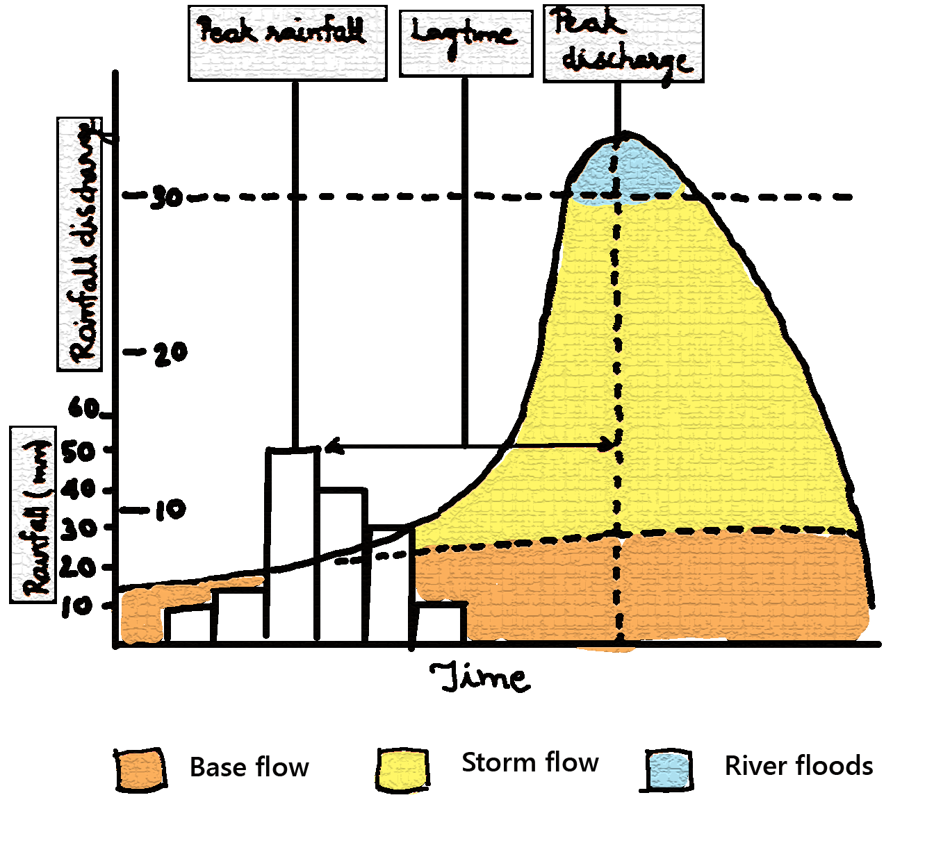
- If we look at a hydrograph from left to right, then the first thing that we can see on a hydrograph is the lag time. This is the delay that occurs between peak rainfall and discharge. Lag time occurs because of the delay between rain falling and water entering the river.
- The second thing that we can see on a hydrograph is called the rising limb. This sits between peak rainfall and discharge and it shows us an increase in river discharge. This occurs because of rainwater that is flowing into the river.
- The third thing that we can see when we look at a hydrograph is the peak discharge level. This is the highest point that is mapped out and it shows us the highest discharge. It is worth noting that hydrographs track changes over time, so you can only see the peak discharge for the period that you are looking at.
- The fourth thing that we can see when we look at a hydrograph is the falling limb. This is the opposite of the rising limb and it shows us the river returning to a normal level.
Flooding
When rivers do flood, there are a number of different factors that could have caused the flooding to occur. Naturally, an increase in river discharge has to be present, but what causes that increase?
- If rainfall becomes heavy, then the level of discharge present can increase quickly. This makes it more likely that a river will spill over its banks. The same could be said when it rains for long periods of time.
- Sometimes, the geology of an area can determine whether or not flooding is likely to occur. Some rocks are permeable and others are not. When rocks are impermeable, the water runs off of them. This causes a rapid increase in discharge.
- Have you already looked at our article about the river valley? If you have, then you will have seen our cross profiles. In the upper course, the sides of the valley are usually incredibly steep. This means that water enters the river much quicker than it otherwise would, causing discharge to increase rapidly.
Hard vs. Soft Engineering
Actions can be taken to prevent flooding before it occurs and deal with flooding after it has occurred. We refer to these things as hard engineering and soft engineering.
Hard Engineering
Hard engineering involves creating man-made structures that can be used to try and control the flow of rivers and prevent flooding.
Some examples of these man-made structures include:
1. Flood Relief Channels
Flood relief channels are usually built to divert water. They usually carry water away from important areas. They can be used to reduce river discharge and some have gates that can control when water is released. Unfortunately, where the relief channels re-join rivers, there will be increased river discharge and this could cause flooding there.
2. Channel Straightening
Channel straightening involves straightening the course of a river. This means that things like meanders can be cut out during the process. This leads to water leaving an area quickly because it doesn’t have as far to travel. Unfortunately, this can cause flooding to occur downstream because of the amount of water that is carried there quickly.
3. Embankments
Embankments are one of the easiest to recognise flood defence systems because they involve walls that are built right along the river banks. Naturally, their presence means that a river can accommodate more water without flooding. It is worth noting that they are quite expensive to build and if they break, the level of damage caused could be devastating.
4. Reservoirs and Dams
Reservoirs and dams usually come hand in hand. We regularly build dams across rivers, but reservoirs form behind them. They can be incredibly useful during periods of prolonged rain, but they can also be used when there are water shortages. Naturally, dams are expensive to build and they result in the loss of the ecosystems that could be found there.
Soft Engineering
Soft engineering involves using what we know about rivers and how we can prepare to deal with floods to reduce the damage that they cause. Some examples of soft engineering include:
1. Preparation
Preparing for floods is quite possibly one of the best days for dealing with them. If you have a plan to deal with a drastic event, then you know what to do when it occurs. For example, a lot of people keep their essentials in a handy place. If buildings are also modified, then less damage will occur. It is worth noting that preparing for something does not mean that you won’t be affected by it.
2. Flood Warnings
If you currently live in an area that is susceptible to flooding, then you will probably have heard flood warnings in the past. These are issued by the Environment Agency across different platforms and they give people time to move their possessions and minimise damage. Remember that these are not preventative and flooding will still occur.
3. Planting Trees
Planting trees might sound like an odd way of preventing flooding, but it actually works really well. They are able to intercept some of the water that falls from the sky before it reaches the river. This increases lag time and reduces river discharge. Naturally, this does mean that less land is available for agricultural purposes.
4. Flood Plain Zoning
If we know that an area is susceptible to flooding, then we can set up flood plain zones. These prevent people from building in areas that are likely to flood. This reduces the amount of damage that could be caused. It also reduces the risk of flooding because there are less impermeable materials for the water to run off.
Frequently Asked Questions for Handling River Discharges and Flooding
What factors can contribute to river discharges and the potential for flooding, and how are they measured and monitored?
Heavy rainfall, snowmelt, and terrain contribute to river discharges. Monitoring includes river gauges and precipitation forecasts.
Explain the concept of a floodplain and its role in absorbing excess water during flooding events.
Floodplains are low-lying areas adjacent to rivers that temporarily store excess water during floods, reducing flood damage.
Describe the methods and strategies employed for managing river discharges and mitigating the impact of floods, including flood defences and floodplain zoning.
Strategies include levees, dams, floodwalls, and zoning regulations that restrict development in flood-prone areas.
Discuss the importance of early warning systems and emergency preparedness in reducing the risk to communities in flood-prone areas.
Early warning systems provide timely alerts, allowing residents to evacuate and authorities to implement flood response plans.
How does climate change contribute to the increased risk of river flooding, and what adaptive measures are being considered to address this challenge?
Climate change can lead to more intense rainfall and higher river flows. Adaptation measures include improved flood defences, land use planning, and climate-resilient infrastructure.