


Landforms of Highland Glaciation
Erosional features in the highlands are generally formed by glaciation while in the low lands glaciation is associated with the depositional features. However, the process of deposition and erosion are not mutually exclusive because the glacier plays combined role erosion, transportation and deposition throughout its course. The erosion of the valley occurs in two ways:
- Abrasion
- Plucking
Plucking of glacier leads to the formation of joints and beds of underlying rocks, tearing individual blocks and drag them away. By abrasion, the glacier scratches, polishes, scraps and scour the floor of the valley with the debris frozen in it. These pieces are potent tools of denudation. Large angular fragments cut deep into the angular rocks which is why all the glaciated floor have the evidence of scratching or striations on it. The finer material polish and smoothens the rock surfaces and creates finely ground rock flour.
The rate of erosion is decided by many factors such as:
- The gradient of the slope
- The velocity of flow
- The weight of the glacier
- Geological structure of the valley
- Temperature of ice
The characteristic features of the glaciated highlands are given below:
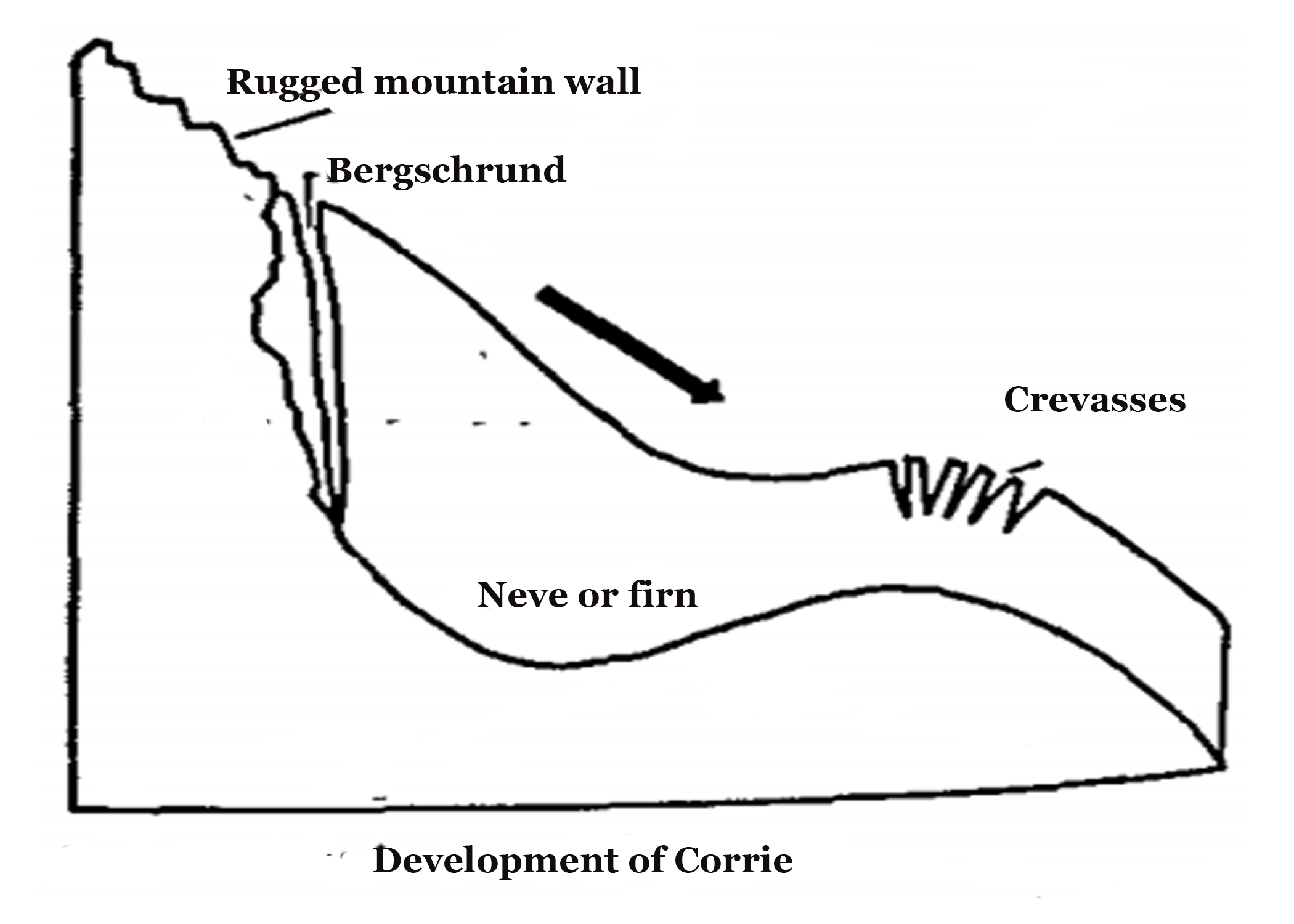
- Corrie or cwm or cirque – The downward movement of the glacier from its snow-covered valley head, and the intensive shattering of upland slopes tend to produce a depression where the firn or nѐvѐ accumulates. The process of plucking operates on the back-wall, steepening it and the movement of the ice abrades the floor, deepening the depression into a steep, horse-shoe shaped basin called a cirque. It is also known as cwm in Wales and Corrie in Scotland. There is a rocky ridge at the end of the Corrie and when the ice eventually melts, water collects behind this barrier to form Corrie Lake or tarn.
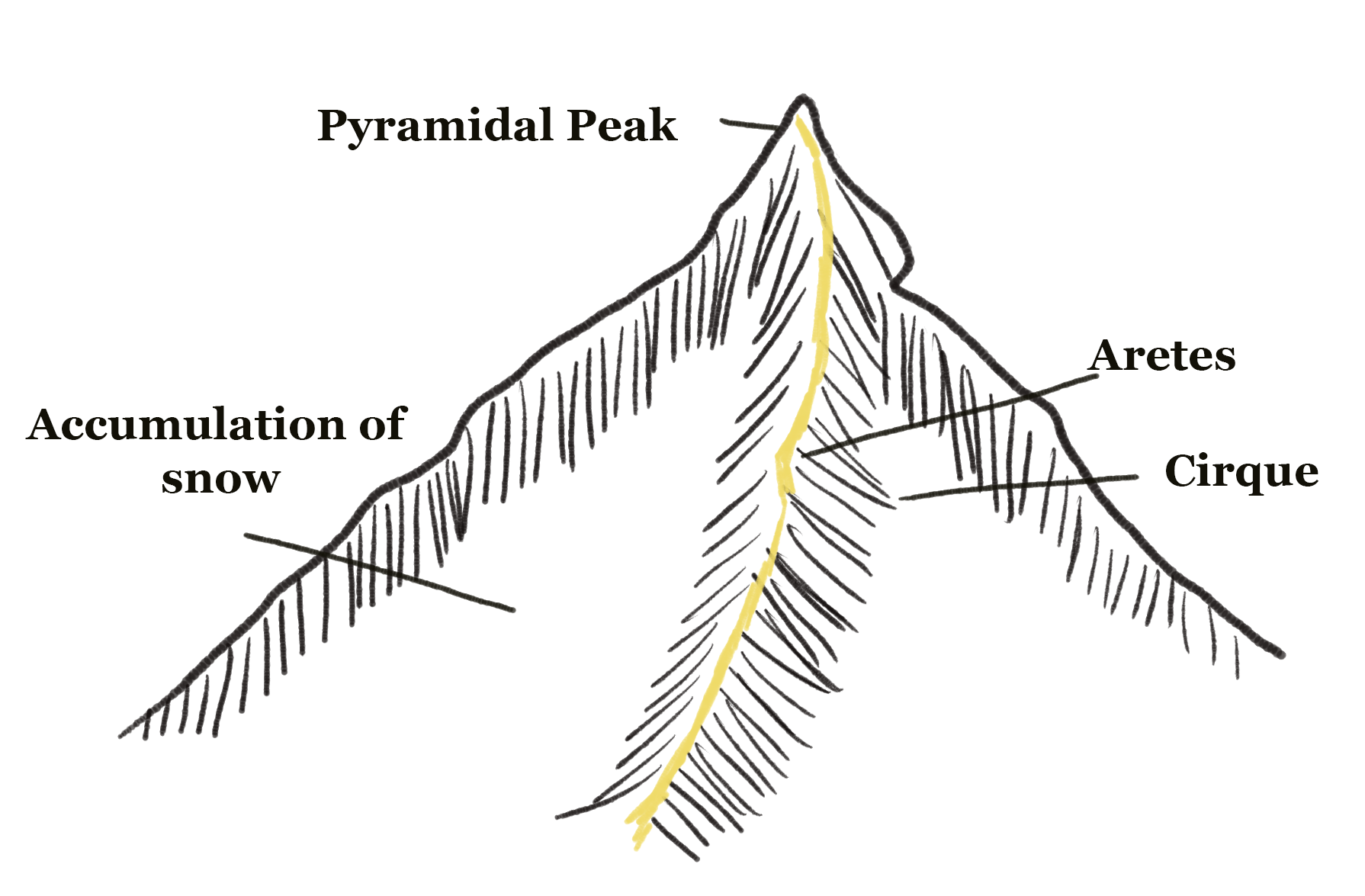
- Aretes and Pyramidal Peaks – When two Corries cut back on the opposite sides of the mountain, knife-edged ridges are formed called aretes. For example – Striding Edge on Helvellyn in Westmorland. Here, three or more cirque cut back together, their ultimate recession will form an angular horn or pyramidal peak. Another example is the Matterhorn of Switzerland.
- Bergschrund – At the top of the glacier, where it starts to leave the snowfield of the Corrie, a vertical, deep crack opens up called Bergschrund (German word) or Rimaye (French). This happens in Summer when ice continues to move out of Corrie and there is no new snow to take its place. In some cases, numerous such cracks are seen. This feature act as an obstacle for climbers. Moving further down, where the glacier negotiates a bend or precipitous slope, more crevices or cracks are formed.
- U-Shaped Glacial Trough – The glacier while downwards is fed by ice from several Corries like river tributaries and begin to erode the sides and the floor of the valley. It scratches and grinds the bedrock taking away with it the rock debris and soil. It straightens any protruding spur on its way. The interlocking spurs are thus blunted to form truncated spurs and the floor of the valley is deepened. A glaciated valley takes the U-shape.
- Hanging Valleys – The main valley is eroded much more rapidly than the tributary valley as it contains a much larger glacier. After the ice has melted a tributary valley, it hangs above the main valley so that its stream plunges down like a waterfall. Such a tributary valley is called a hanging valley and form a natural head of water for generating hydro-electric power.
- Rock basins or rock steps – A glacier erodes and excavate the bedrock in an irregular manner. The unequal excavation gives rise to many rock basins later filled by lakes in the valley trough where a tributary valley joins the main valley, the extra weight of the ice in the main valley cuts deeper into the floor of the valley at the point of convergence forming a rock step. A series of such rock steps may also be formed due to different degrees of resistance to glacial erosion of the bedrocks.
- Moraines – These are made of the pieces of rock or rock debris that is carried along by glacier and usually consist of round particles which can be big like boulders and small like the particle of flour. Lateral moraines develop at the side of the ice flow and terminal moraines at the foot, indicating the maximum advance of the glacier.
Landforms of glaciated lowlands
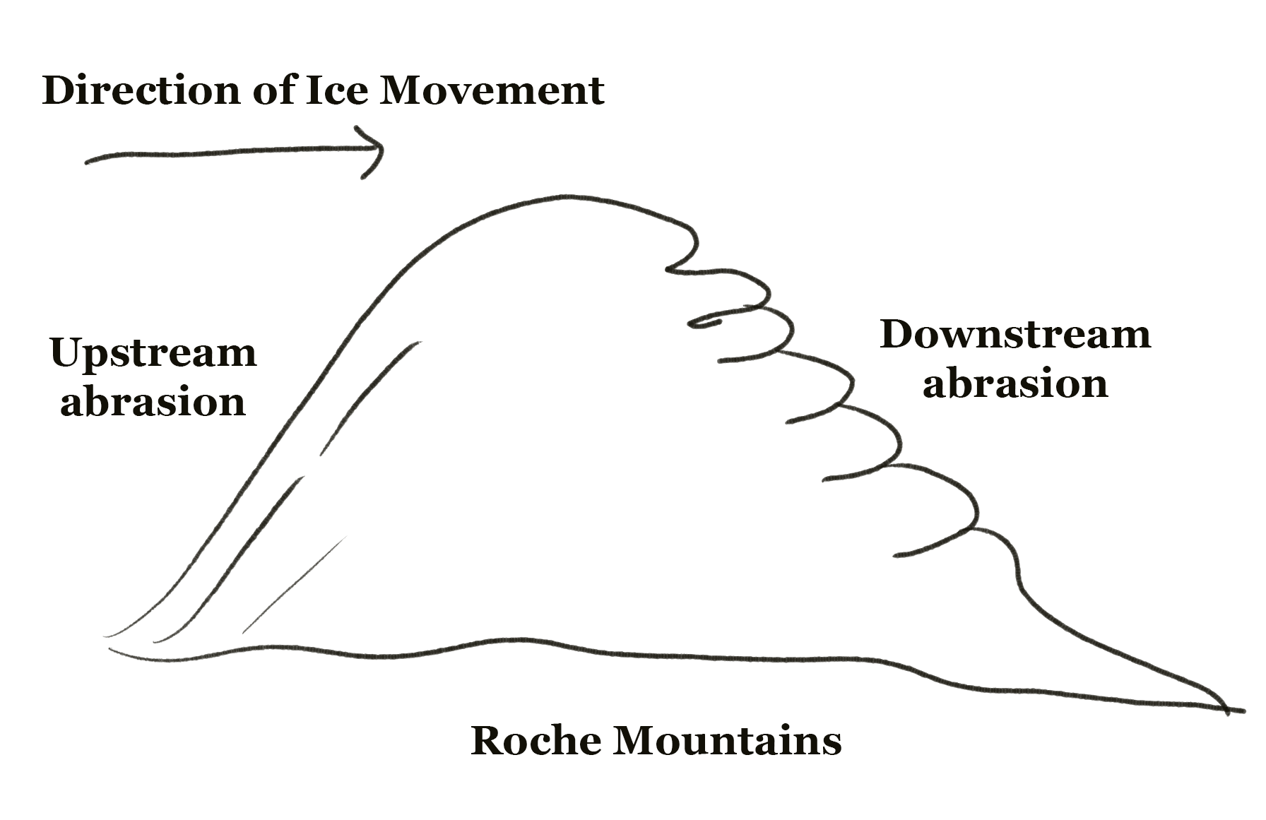
These are generally depositional in nature and are brought by both continental ice sheets and glaciers. The later leaves behind the eroded materials in only restricted areas. The imprint of ice-sheets on the landscape is far more widespread because they advanced through the large areas during the Ice Ages, removing any surface soil and rock debris on their way. Though most of the glaciated lowlands have depositional features, where rock masses project above the level surface, they result in striking features of erosion, such as the Roche Moutomme and crag and tail:
- Roche Moutommee – It is a resistance residual rock hummock. The surface is striated by ice movement. Its upstream side is smoothed by abrasion and its downstream side is roughened by plucking and is much steeper. The term Roche Moutommee is used to describe such a feature because it resembles a sheepskin-wig once worn in France Roches Moutommees are found in both highland and lowland glaciated regions.
- Crag and Tail – The crag is a mass of hard rock with a precipitous slope on the upstream side, which protects the softer leeward slope from being completely worn down by the on-coming ice. Thus, it has a gentle tail strewn with the eroded rock debris.
Example – Castle Rock of Edinburgh, Scotland.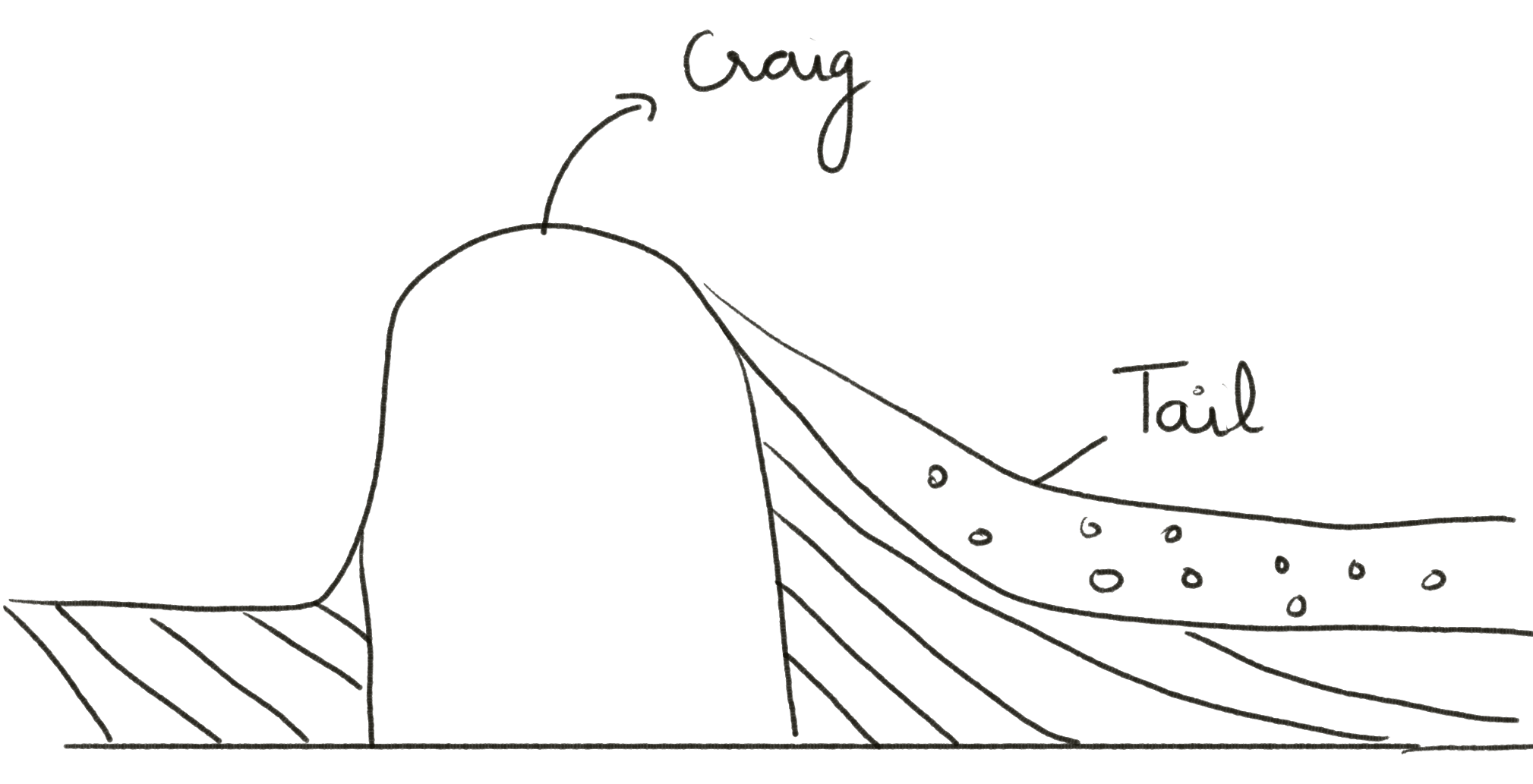
- Drumlins – These are swarms of oval, elongated ‘whale-back’ hummocks composed completely of boulder clay with their elongation in the direction of ice flow, that is on the downstream side. They are low hills varying from a few yards to 400 feet in height and maybe a mile or two long. Example – County Down in Northern Ireland and the glaciated plain around the Great Lakes in North America.
Frequently Asked Questions
What are landforms of glaciation, and how are they formed by glaciers?
Landforms of glaciation include features like cirques, moraines, fjords, and aretes, which are shaped by the erosional and depositional action of glaciers as they move and melt.
How does the movement of glaciers contribute to the creation of U-shaped valleys?
Glaciers carve U-shaped valleys through the abrasion and plucking of rocks and sediments along their path, resulting in distinctive valley shapes.
What are the environmental impacts of landforms of glaciation on local ecosystems and landscapes?
Landforms of glaciation can create unique habitats, influence drainage patterns, and contribute to the formation of freshwater resources like lakes and rivers.
Where in the world are significant landforms of glaciation typically found?
Notable landforms of glaciation are found in regions with past or present glacial activity, including areas like the Alps, Himalayas, Patagonia, and the Arctic.
How do scientists use landforms of glaciation to study Earth’s geological history and climate change?
Studying these landforms helps scientists reconstruct past glacial periods, understand climate variations, and assess the impact of climate change on glaciers and landscapes.