What are Plates?
Tectonic areas, or Plate tectonics is the scientific explanation for the formation and changes of Earth’s surface both in the past and present, ranging from the vast ocean channels to towering mountains. The theory proposes that Earth’s outermost shell is comprised of several large plates that move over the mantle, a rigid layer located above the core.
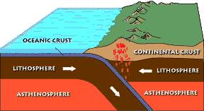
These plates act like a solid outer shell in contrast to the mantle’s pliable and molten composition. The lithosphere, which is about 100 km (60 miles) thick, forms the strong and unyielding outermost layer of the Earth’s surface and is connected to the mantle’s uppermost layers. The asthenosphere lies beneath the lithosphere and is relatively flexible, which enables the lithosphere to move around. However, the exact mechanism for this movement is still a developing concept.
What is the History of Plate Tectonics?
Plate tectonics is a scientific theory that was developed between the 1950s and 1970s, building on the earlier idea proposed by geologist Alfred Wegener in 1912 regarding the drifting of continents. While Wegener lacked a precise explanation for this phenomenon, scientists today have a better understanding of it through the concept of plate tectonics.
This theory is a unifying principle in geology that explains how the Earth’s surface is composed of large tectonic plates that move in relation to one another. Prior to the development of plate tectonics, geologists had to come up with unique explanations for the geological features of each region. However, with the introduction of this theory, it became possible to describe all geological aspects as a result of the movement of these tectonic plates.
Tectonic Areas: How many tectonic plates are there?
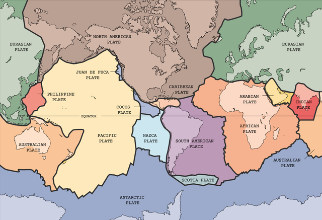
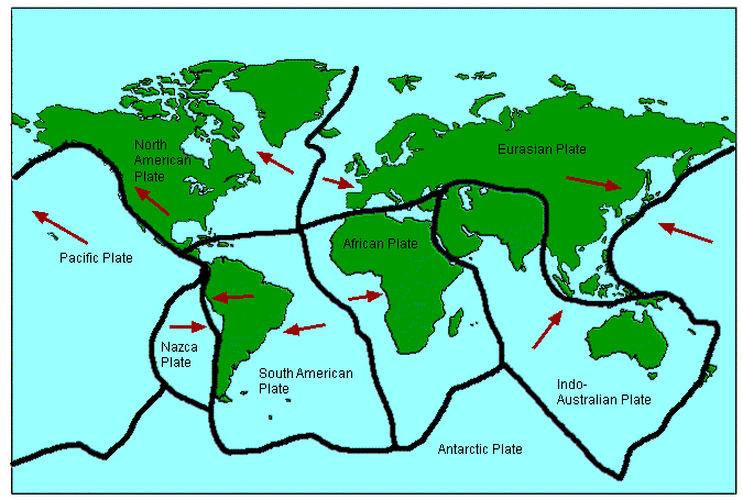
World Atlas shows that there are nine major tectonic plates, each named after the prominent landforms found on them. These significant plates are the North American, Pacific, Eurasian, African, Indo-Australian, Australian, Indian, South American, and Antarctic plates. Among these, the largest is the Pacific Plate, spanning an area of 39,768,522 square miles (103,000,000 square kilometers), mostly located beneath the ocean. The plate is currently moving in a north-west direction at a speed of approximately 2.78 inches (7 cm) per year. Apart from these nine major plates, there are also several smaller plates dispersed throughout the world.
How does plate tectonics work?
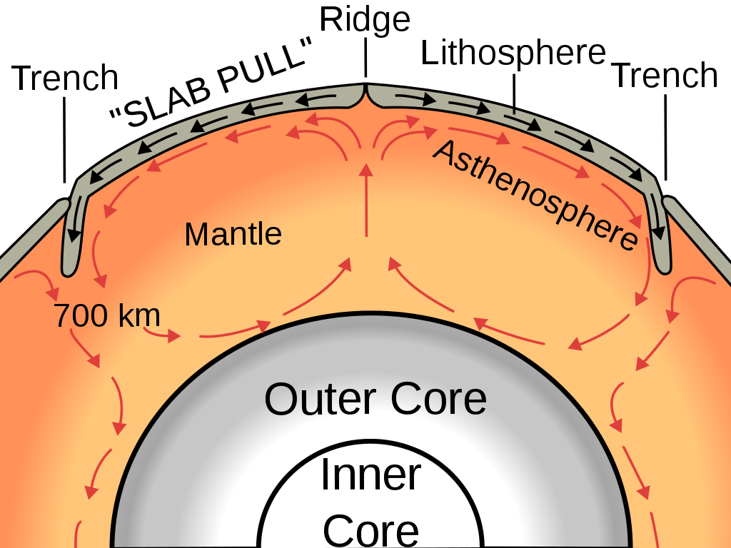
Convection in the mantle is considered the primary driving force behind plate tectonics. The hot material near the Earth’s core rises, while the cooler mantle rock sinks, much like a pot of boiling liquid on a stove. This convection process propels the movement of tectonic plates through a combination of pushing and spreading at mid-ocean ridges and pulling and sinking at subduction zones, according to scientists. Researchers are still investigating and discussing the various factors that contribute to plate movement.
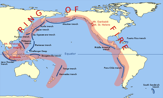
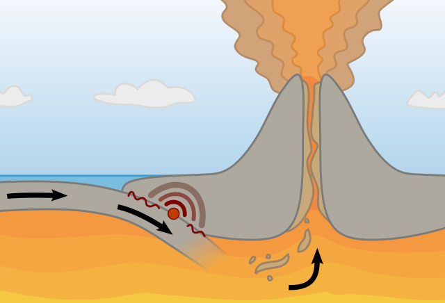
Mid-ocean ridges are fractures between tectonic plates that cover the Earth’s surface like the seams on a baseball. These areas experience eruptions of hot magma, which leads to the formation of new oceanic crust and the separation of the plates. At subduction zones, two tectonic plates collide, and one plate slides beneath the other and sinks into the mantle layer beneath the crust. The cooling and sinking plate drags the crust behind it, causing it to descend. Along subduction zones, there are several massive volcanoes, such as the Ring of Fire, which encompasses the Pacific Ocean.
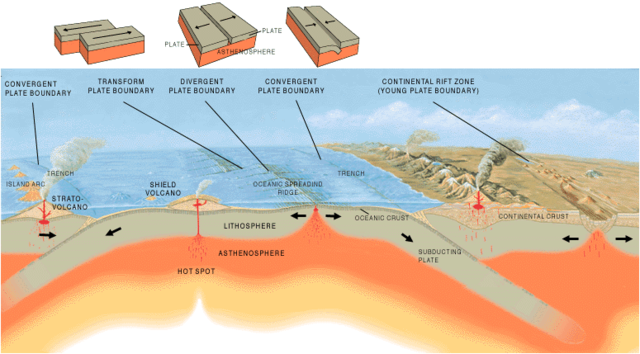
What are Plate Boundaries?
Subduction zones, also known as convergent boundaries, are one of the three types of plate boundaries, the others being divergent and transform boundaries.
At divergent boundaries, two plates move apart from each other, such as at mid-ocean ridges or continental rift zones like the East Africa Rift.
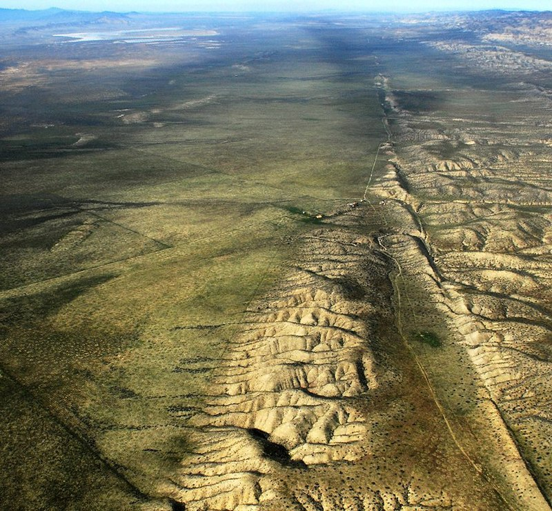
Transform boundaries, on the other hand, occur when plates slide past each other horizontally, such as at California’s San Andreas Fault, where the North American and Pacific plates grind past each other with a mostly lateral movement.
Convergent Boundaries
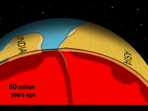
When plates carrying continents collide, the crust folds and buckles to form mountain ranges. Around 55 million years ago, India and Asia collided, gradually giving rise to the Himalayas, the tallest mountain system on Earth. As the process continues, the mountains continue to rise, and Mount Everest, the highest point on Earth, may be slightly taller tomorrow than it is today.
These convergent boundaries also occur where an oceanic plate dives, in a process called subduction, under a continent. As the overlying plate lifts, it also forms mountain ranges. Additionally, the diving plate melts and is often erupted in volcanic eruptions, such as those that formed some of the mountains in the Andes of South America.
Volcanoes are as dangerous as they are magnificent, with over 50 eruptions occurring on our planet every year.
At oceanic convergent boundaries, one plate typically dives beneath the other, forming deep trenches like the Mariana Trench in the North Pacific Ocean, the deepest point on Earth. These types of collisions can also temporarily submerge volcanoes that eventually join up with island arcs like Japan.
Destructive Boundaries
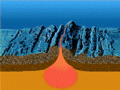
In certain oceanic boundaries, magma from deep within the Earth’s mantle ascends towards the surface, causing at least two plates to move apart. This process gives rise to mountains and volcanoes along the ridge and expands the vast ocean basins. A single mid-ocean ridge system connects the world’s oceans, making it the longest mountain range on Earth.
Onshore, enormous troughs like the Great Rift Valley in Africa form where plates are pulled apart. If the plates continue to move, millions of years from now, eastern Africa will split from the continent to form a new landmass, and a mid-ocean ridge will mark the boundary between the plates.
Transform Boundaries
The strike-slip faults, like the San Andreas Fault in California, are a type of boundary where two plates slide past each other. Unlike other boundaries, they don’t create prominent landforms like mountains or oceans, but their movement can trigger devastating earthquakes. In 1906, an earthquake along the San Andreas Fault caused massive destruction in San Francisco.
Even the Earth Reuses and Recycles
Despite the Earth’s age of 4.53 billion years, the oceanic plate’s continuous recycling under subduction zones means that the oldest oceanic crust is only approximately 200 million years old. The oldest oceanic rocks can be located in the northwestern Pacific Ocean and the eastern Mediterranean Sea. In contrast, portions of continental crust are even older, with sizable formations that are at least 3.8 billion years old discovered in Greenland.
Geoscientists can reconstruct the history of Earth’s continents using clues from rocks and fossils. While it is unclear exactly when modern plate tectonics began, some evidence suggests it may have started as early as 3.5 billion years ago, while others place the timeline closer to 3 billion years ago. However, we do know that continental crust exists that is at least 3.8 billion years old, which indicates plate tectonics may have been happening in some form at that time.
Over time, continents come together to form supercontinents, such as Rodinia, which was assembled around 1 billion years ago and is associated with a global glaciation event. Pangaea, the next supercontinent, formed around 300 million years ago when Africa, South America, North America, and Europe collided, leaving behind fossils and rocks that helped scientists understand continental movement.
When plates converge, they can also create mountain ranges. For example, the collision between India and Asia around 55 million years ago gave rise to the Himalayas.
Interesting Facts about Plates
- In the 16th century, William Gilbert proposed that the Earth behaves like a giant magnet, but he couldn’t explain his theory in detail.
- Rocks found in Europe indicated that the North Pole used to be located near Hawaii.
- Earth’s core has a magnetic field, which extends to its surroundings.
- A geologist Harry Hess speculated the seafloor spreading magma outwards and a while later cooling off into mountain structures.
- Geologist Harry Hess proposed that magma spreading out from the seafloor creates mountains.
- Jacques Cousteau, an explorer who died in World War II, developed equipment for exploring the ocean floor.
- US geologists hypothesized that the solid plates can move due to the fluid mantle, later calling it plate tectonics.
- Evidence from rock layers, such as those in the Swiss Alps, shows that continents can form mountains.
- The San Andreas Fault is an example of transform plates shaping the Earth.
- Plate movement produces varying degrees of friction when plates rub against each other.
- Geologists have mapped regions of volcanic and seismic activity and seafloor spreading, which form a system of plates on Earth’s surface.
- These plates make up the lithosphere, the hard outer layer of Earth that floats above the hotter, more fluid asthenosphere.
- The asthenosphere can flow under the weight of the lithosphere, allowing the plates to move over it in a slow, ongoing process.
- The plates that structure the lithosphere skim over a hot, semisolid layer of the mantle that is known as the asthenosphere.
Plate Boundaries
- Divergent cutoff points: where the plates are moving interminably from one another, and new crust is formed from the mantle material.
- Convergent cutoff points: where plates are progressing toward one another effect. The edge of one plate may plunge under the edge of the other one. The crust is crushed, softening down into mantle material.
- Transform limits: where plates are sliding past one another. No crust is destroyed, and no new crust is formed.
The plate advancements at these cutoff points produce distinctly different effects. These effects depend upon what kind of plates are incorporated.
Read more about Plate Tectonics
Frequently Asked Questions
What are tectonic plates and how do they interact?
Tectonic plates are large sections of the Earth’s crust that float on the semi-fluid asthenosphere. They interact at plate boundaries, where they can collide, move apart, or slide past each other.
What types of geological features are associated with tectonic plate boundaries?
Tectonic plate boundaries are associated with features like earthquakes, mountain ranges, volcanic activity, oceanic trenches, and mid-ocean ridges.
How does subduction occur at convergent plate boundaries?
Subduction occurs when one tectonic plate is forced beneath another due to differences in density. This can lead to the formation of volcanic arcs and deep ocean trenches.
What is seafloor spreading, and where does it primarily occur?
Seafloor spreading is the process by which new oceanic crust is formed at mid-ocean ridges as tectonic plates move apart. The Mid-Atlantic Ridge is a well-known example of seafloor spreading.
How does the movement of tectonic plates contribute to the distribution of natural resources?
Tectonic plate movement influences the formation of mineral deposits, oil and gas reservoirs, and geothermal energy sources. Areas near plate boundaries often have high resource potential.
References
- Conservative plate boundaries and transform faults. (n.d.). Retrieved from open.edu: https://www.open.edu/openlearn/science-maths-technology/science/geology/plate-tectonics/content-section-3.8
- Continental Drift and Plate Tectonics . (n.d.). Retrieved from The Geography Site: http://www.geography-site.co.uk/pages/physical/earth/tect.html
- Destructive, constructive and conservative plate margins Flashcards. (n.d.). Retrieved from BrainScape: https://www.brainscape.com/flashcards/destructive-constructive-and-conservative-4296151/packs/6448855
- fun facts. (n.d.). Retrieved from Plate tectonics: http://platetectonics10.weebly.com/fun-facts.html
- Plate Tectonics. (n.d.). Retrieved from National Geographic: https://www.nationalgeographic.com/science/earth/the-dynamic-earth/plate-tectonics/
- Plate Tectonics. (n.d.). Retrieved from OpenLearn: https://www.open.edu/openlearn/science-maths-technology/science/geology/plate-tectonics/content-section-3.3
- Plate Tectonics. (n.d.). Retrieved from Geography Revision: https://geography-revision.co.uk/a-level/physical/plate-tectonics/
- Primary School Geography Encyclopedia. (n.d.). Retrieved from parkfieldprimary.com: http://geography.parkfieldprimary.com/hazards/plate-tectonics
- What is a tectonic plate? (1999, May 5). Retrieved from USGS: https://pubs.usgs.gov/gip/dynamic/tectonic.html
- What Is Plate Tectonics? (n.d.). Retrieved from Live Science: https://www.livescience.com/37706-what-is-plate-tectonics.html