What is Erosion?
Erosion is a phenomenon which occur when water breaks a material into smaller pieces. For example, if you put a big rock in the middle of a fast-flowing river, with the passage of time that same will decrease in mass. The high-speed water thrashing into the rock will inevitably break the rock little by little.
Erosion not occurs in rivers but it happens on beaches as well. The waves of water slam into the land rocks regularly. Everyday without any rest, therefore, the land rocks get smaller and you can clearly see the signs of erosion on those rocks.
Some people have declared erosion a form of art because the way it re-shapes a rock is very beautiful and stunning. Some of the world’s beautiful landmarks are caused by erosion. Even rainfall causes erosion. Drops of water falling from the sky on buildings, mountains and valley will eventually cause erosion.
The basic principle behind erosion is that the water polishes a material until it become smooth. Along this process little bits of that material are broken which explains the reduction in size. Rocks near a river are mostly round and smooth, that is because of erosion. Cliffs near a sea are also susceptible to erosion.
What is Landform?
Landform is a structure made of rock or landmass which has a unique shape due to natural causes. Mountains, valleys, beaches, canyons and islands are all considered landforms. Each has its own uniqueness. For example, an island is a beautiful landform which has its own characteristics such as water on all sides, different climate etc. While the mountain ranges have their own attributes such as cold weather, rigid and rough terrain etc. Mountains are formed by the plate activity within the earth. Constructive and destructive plate movements are responsible for creating mountains and volcanos throughout the entire planet.
There are all sorts of landforms on the earth such as canyons. When a river flows through a region, with the passage of time it erodes the land steadily. After decades of erosion, the land turns into a canyon. The Grand Canyon is a great example of erosion, it is the largest canyon on the planet made through erosion.
What are the Types of Landforms?
There are many types of landforms formed due to deposition and erosion. Here are some of these types:
- Canyon
- Cape
- Coastline
- Continental Shelf
- Delta
- Desert
- Glacier
Canyon
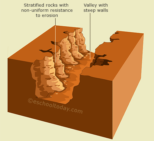
The striking highlights of a canyon are steep precipices with profound valleys going through them. They are framed where rocks are stratified on a level plane and are related to rocks that don’t have uniform protection from erosion.
The valley could conceivably have water in them. The canyon can be seen both ashore (generally called River Canyons) and on the sea floor (likewise called submarine canyons). Canyons are otherwise called chasms, or mountain canyons.
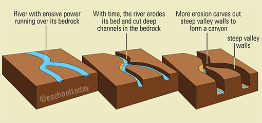
River canyons structure when the weight of a waterway cuts a profound and tight channel through its bed. Waterways ordinarily stream from high rise to low rise. In this manner, the erosive intensity of a stream is more as it runs downhill. With time, it will dissolve its bed until it is at a similar rise of the greater water body into which it channels.
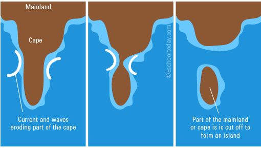
Cape
A cape is a raised landmass that expands profoundly into a water body, for the most part, the ocean. It is a generally a beachfront component. From above, it is an unmistakable change from the typical pattern of the coastline. There are such huge numbers of capes of numerous sizes arranged on the banks of the considerable number of landmasses.
A cape and a promontory can be confounding. Here is the distinction:
A cape is associated with the territory by a bigger mass of land than a landmass, which is associated with a flimsy landmass. At the end of the day, a landmass is just about an island.
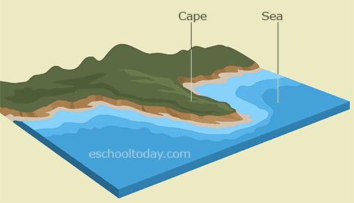
A cape is circumscribed by water on different sides, however, a landmass is flanked by water on three sides.
Capes are shaped in three different ways: by erosion, sea flows, and icy mass. Contingent upon the idea of rock material of the cape, one can tell its arrangement.
Rough capes are cut out of erosion by sea flows, where the gentler stone material is washed away, leaving the rough piece.
Sandy capes are an indication of two sea flows conflicting and storing fine material (rock and dregs) where they meet. With time, the silt heap up and structure a pointed landform anticipating into the ocean.
Ice sheets can likewise cut their way into a land zone and store moraine (sand, silt, and rock) after they dissolve away.
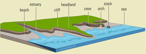
Coastline
A coastline is just the junction for land and the oceans or seas. It incorporates all the sea shores, precipices, capes, caverns, narrows and estuaries that line up toward the finish of the land. These highlights may all be found near one another on a coastline.
Coastlines change with time. At the point when ocean levels rise and fall, coastlines are re-formed. Steady erosion or residue develop likewise changes the shape and type of coastlines. New highlights, for example, stacks and buckles are shaped and more seasoned highlights likewise separate.
The coastlines of the world’s mainland measure around 312,000 km (193,000 miles)
Coastlines are framed from multiple points of view — the store of dregs conveyed by sea flows and waterways entering the ocean, and furthermore by erosion by waves. Rough and rough coastlines are normally framed by erosion while sandy sea shores, sedimentary and shallow coastlines are generally those shaped from sedimentary stores. Earth or structural developments can likewise push up new landforms or spill out new magma from close by mountains, making new waterfront features.
Continental Shelf
This is the piece of the landmass that reaches out into the ocean with no huge incline and with shallow waters over it.
Two significant terms are typically utilized in portraying the continental shelf: The shelf break and the continental slant.
The shelf break is the slanted edge where the remote ocean starts. The Slope is the part that comes after the break, connecting the break to the sea floor. The profundity of the water in the continental rack is about 60M (200ft).
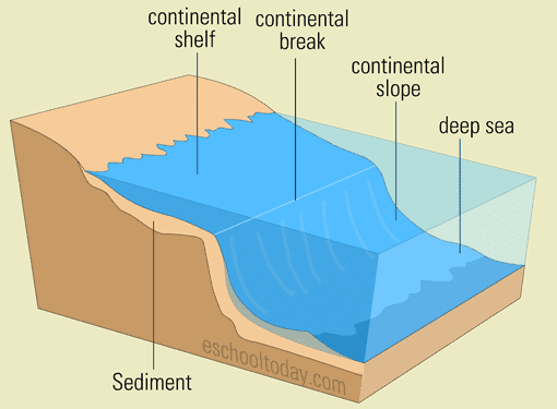
Continental shelfs are significant in light of the fact that they are viewed as limit of the landmasses, and not the unmistakable piece of the coastline. Since the shelf is secured by shallow waters, there is sufficient daylight entrance and that makes it an incredible condition for some, living beings (plant and creatures)
Continental shelfs are normally shaped from the stores of endured seaside landforms and furthermore from silt saved by waterways, it bolsters from. Over numerous years, dead weeds and creatures likewise settle down the bed and turn out to be a piece of the rack.
Delta
Where do most streams lead to — the ocean! A stream at its source streams quick in a genuinely straight way. Before a waterway finds a good pace, its speed is altogether decreased and starts to wander, which implies it streams in an awe-inspiring nature.
At this endpoint of a waterway, there is typically a wetland that is looking like a triangle when seen from above on the grounds that the stream isolates into numerous littler channels called distributaries. A distributary structures when the speed of the waterway is low to such an extent that, the water just can’t remain on course, but instead discovers its own ways to the ocean. The low speed of the stream likewise makes it wander (stream in bends). This residue saved wetland where a stream meets the ocean to sustain into it is known as a delta.
A delta is a residue and sediment saved landform shaped by waterways in their lower course directly at where they enter the ocean.
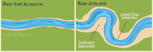
A delta isn’t an estuary. An estuary is a waterway found at places where streams meet the ocean, whiles a delta is a landmass. Estuaries have a blend of freshwater from land and some salty ocean water from the sea.
The piece of the delta that is impacted by the waterway’s movement is known as the Upper Delta. The opposite side which is impacted by the movement of the sea is known as the Lower Delta.
A delta structures when water loses its speed and capacity to convey its heap (silt) and stores them at the base of the stream. With time, the silt develops shaping new land. It is critical to realize that not all waterways have Deltas. Deltas are just conceivable when the progression of the water is exceptionally moderate enough for residue and dregs to be saved.
Desert
A desert is just a parched land (excessively dry or fruitless to help vegetation) with almost no precipitation. It is realized that about 33% of the world’s property are comprised of deserts. Some normal highlights found on deserts incorporate stone platforms, desert asphalts, and sand rises.
Highlights of a desert include:
- Less than 10 inches of precipitation every year
- Evaporation is more or equivalent to precipitation
- Has meagre conveyance of vegetation because of low dampness
- They, for the most part, have little overcast spread.
- Deserts might be cold or hot. Deserts near the equator can have temperatures of over 38C (100F) and freezing evenings.
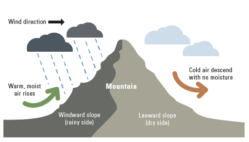
One way that a desert structures is when downpour mists are moved by the wind into high mountains. Condensation happens and downpour whenever constrained down on that side of the mountain, leaving the opposite side dry. The dry side of the slant presently turns into the downpour shadow with almost no stickiness.
Glacier
Glaciers are found in freezing locales, for example, the Antarctica and Arctic areas, Greenland and cold pieces of Canada. In straightforward terms, a glacier is moving ice. This implies the accessibility of day off certain slants are conditional for glaciers to happen.
How do glaciers structure:
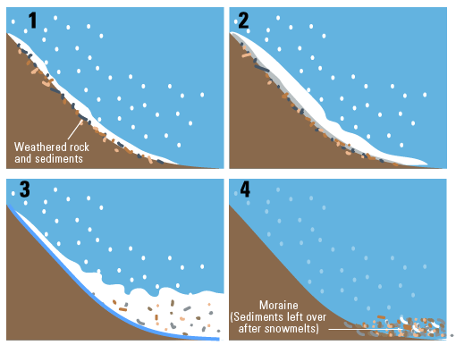
1—Glacier starts with parcels and heaps of snowfall, in areas where the ice once in a while liquefies. They fall on mountain inclines and over endured rock material.
2—After numerous long periods of rehashed snowfalls, the ice is compacted under its own weight. The compacted day off ice becomes heavier with considerably more snowfall.
3—Sometimes, the land heats up and liquefies a slight layer of the stone surface and the strong ice and day off. This makes the ice slide and smashes under its own weight. As they move along the mountain incline, they sever shakes superficially (scraped area) and convey them downhill.
4—When the ice liquefies, they shake, sand, mud and all the trash are abandoned to shape a moraine. In freezing atmospheres, the ice never dissolves, considerably after the move downhill. Now and again they end up in the oceans and buoy on the water surface.
Island
An island is a landmass encompassed by water. They can be little or huge in size. A few islands are framed on the continental shelf and they are continental islands. Others are framed a long way from the continental shelf, and they are known as oceanic islands.
Volcanic ejections in the ocean can make new terrains by accumulating magma and setting in the ocean. Tectonic plates can likewise collapse the seabed and push new land up to the water surface.
Continental islands:
Continental islands are framed when parts of the territory are split off or disintegrated away by wave activity, leaving a landmass without anyone else.
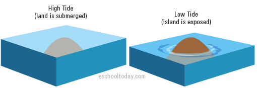
Tidal islands:
Changes in the ocean level can likewise uncover islands. These are called tidal islands.
Barrier islands:
Flows and waves can likewise accumulate silt and sand in one area and with time, incorporate up with an island. These are generally low-lying islands, running corresponding to the terrain, and for the most part sand as the landmass. This sort of island is known as a barrier island.
Read more about Desert Features Created by Wind Erosion
Frequently Asked Questions
What are landforms of erosion?
Landforms of erosion are geological features shaped by the removal of rock and soil through processes like wind, water, and glaciers.
How are valleys and canyons formed through erosion?
River erosion carves valleys and canyons over time as flowing water wears away the surrounding rock, creating distinctive V-shaped or U-shaped landforms.
What are hoodoos and how are they created?
Hoodoos are tall, thin spires of rock formed by differential erosion, where harder rock caps protect softer rock underneath from being eroded.
How does coastal erosion shape features like sea arches and stacks?
Coastal erosion by waves and currents can erode softer rock layers, forming sea arches where a hole is worn through, and stacks, isolated columns of rock.
How do glaciers contribute to landforms of erosion?
Glaciers erode the landscape by scraping and plucking, forming features like cirques, arêtes, and hanging valleys as they move downhill.
References
- What is a Canyon Landform? (n.d.). Retrieved from EschoolToday: http://www.eschooltoday.com/landforms/what-is-a-canyon-landform.html
- What is a cape? (n.d.). Retrieved from EschoolToday: http://www.eschooltoday.com/landforms/what-is-a-cape-and-peninsula-landform.html
- What is a coastline? (n.d.). Retrieved from EschoolToday: http://www.eschooltoday.com/landforms/what-is-a-continental-shelf-landform.html
- What is a Coastline? (n.d.). Retrieved from EschoolToday: http://www.eschooltoday.com/landforms/what-is-a-coastline-landform.html
- What is a delta landform? (n.d.). Retrieved from EschoolToday: http://www.eschooltoday.com/landforms/what-is-a-delta-landform.html
- What is a Desert landform. (n.d.). Retrieved from EschoolToday: http://www.eschooltoday.com/landforms/what-is-a-desert-landform.html
- What is a glacier? (n.d.). Retrieved from ESchoolToday: http://www.eschooltoday.com/landforms/what-is-a-glacier.htmlWhat is an Island Landform? (n.d.). Retrieved from ESchoolToday: http://www.eschooltoday.com/landforms/what-is-an-island-landform.html