Landforms of deposition are a captivating aspect of Earth’s dynamic geological processes, contributing to the ever-evolving tapestry of our planet’s surface. These landforms, shaped by the deposition of sediments carried by wind, water, and ice, offer a vivid glimpse into the intricate interplay between natural forces and the Earth’s topography. Whether it’s the creation of expansive deltas, mesmerizing alluvial fans, or the formation of enchanting beaches, each landform of deposition narrates a unique geological story. In this exploration, we will venture into the world of these landforms, understanding their formation, significance, and the remarkable role they play in molding the diverse landscapes we encounter. Join us on this journey as we uncover the secrets of landforms created through the gentle touch of deposition processes.
What are Landforms of Deposition?
The Coastal Dynamics: Balancing Erosion and Deposition
Coastal regions are subject to the relentless forces of nature, where two primary geological processes, erosion and deposition, often vie for supremacy. A quintessential example of an erosional coastal landscape is found along the rugged Pacific coast of Canada and the United States, where the ceaseless battering of waves and powerful ocean currents erode shorelines and carve distinctive features.
In stark contrast, the Atlantic and Caribbean coasts of the United States are dominated by depositional processes, where sediments carried by rivers and transported by marine currents contribute to the gradual expansion of coastlines. However, even in these seemingly polarized scenarios, the coexistence of both erosion and deposition is a pervasive reality, albeit in varying degrees.
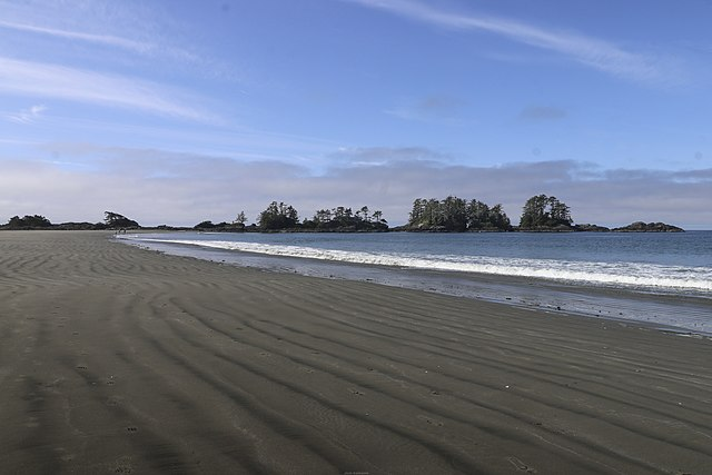
This dynamic interplay is vividly exemplified in the Tofino region of Vancouver Island, where erosional forces shape rocky headlands, while within sheltered inlets, depositional landforms predominate. Along deposition-prone coasts, coastal sediments are in constant flux, with material eroded from some areas being transported and deposited in others, illustrating the perpetual transformation of these captivating coastal environments.
Seasonal Influence of Landforms of Deposition
Winter and summer bring about distinct changes in erosion and deposition processes that shape coastal landforms. These seasonal variations are primarily driven by shifts in weather patterns, ocean currents, and the interplay between various natural forces. Let’s delve into how winter and summer impact erosion and deposition along coastal areas:
Winter:
- Increased Erosion: Winter often witnesses more frequent and severe storms, characterized by strong winds, heavy rainfall, and elevated wave energy. These conditions result in higher erosion rates along the coast. The combination of storm surges and intense wave action can strip away significant amounts of sand and sediment from beaches and shorelines.
- Coastal Retreat: The elevated erosion during winter can lead to coastal retreat, where shorelines move inland as sediment is eroded and removed from the coastline. This is particularly evident in areas prone to winter storm events, such as the northeastern coast of the United States.
- Transport of Sediments: Winter storms can transport eroded sediments and debris to offshore areas and create sandbars. These underwater sandbars may shift or evolve throughout the winter due to changing wave dynamics.
Summer:
- Deposition and Beach Rebuilding: In summer, milder weather conditions often prevail, with reduced storm activity. This allows for the deposition of sediments along the coast. Beaches tend to rebuild during the summer months as gentle waves carry sand and sediment back to the shoreline.
- Sandbar Formation: Summer can see the formation or expansion of sandbars near the coast, particularly in areas where sediments are transported offshore during winter storms. These sandbars may provide natural protection to the coastline.
- Longshore Drift: In many coastal regions, summer promotes longshore drift—a process where sediments move parallel to the shoreline due to the action of waves. This can result in the redistribution of sand and sediment along the coast.
- Accretion: Summer’s lower energy wave conditions allow sediments to settle and accumulate in depositional landforms like spits, barrier islands, and coastal lagoons. These landforms thrive during the summer season when deposition outpaces erosion.
Landforms of deposition
Coastal landforms of deposition happen where the gathering of sand and shingle is more prominent than it is expelled. This is especially the situation where productive waves are predominant or where there is a bottomless measure of beach material provided.
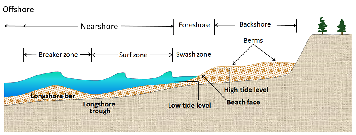
Beaches are dynamic environments for the cradle between land and ocean. They have three primary segments, the nearshore (where the land starts to influence the ocean), the foreshore (surf zone) and the backshore (as a rule, over the elevated tide mark). The backshore commonly includes the material collected by storm waves.
Wave zones and beach morphology
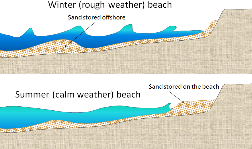
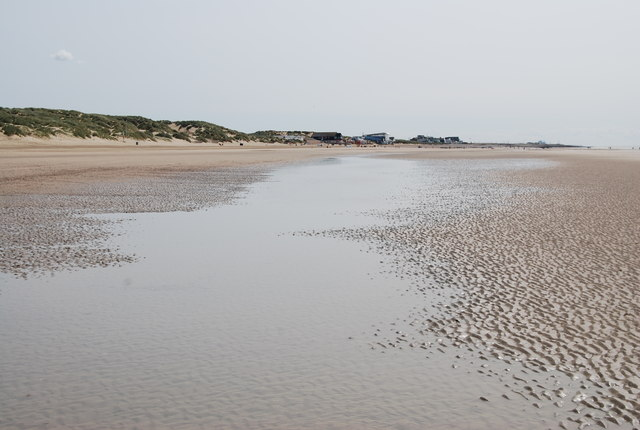
The configuration of a beach tends to undergo seasonal variations over the course of a year. Generally, beaches display a steeper profile in the summertime. This inclination is attributed to the prevalence of constructive waves during the summer, which deposit a substantial amount of material at the uppermost portion of the beach. As the upper beach accumulates sediments, the swash – the seaward movement of water on the beach – becomes gentler due to a greater portion of the water seeping into the sand through infiltration, rather than flowing directly down the beach.
Conversely, the winter season introduces the dominance of destructive waves. These waves are apt to deposit material at the lower portion of the beach. The destructive swash, however, is impeded from progressing further up the beach, as the backwash from the previous breaking wave erases its progress. Within the foreshore zone, ridges and runnels take shape parallel to the shoreline. Ridges refer to elevated areas of the foreshore compared to the adjacent shore, while runnels are depressions between these ridges. These runnels are intersected by channels that facilitate water drainage down the beach.
This continuous interplay of constructive and destructive waves, along with the associated deposition and erosion processes, contributes to the ever-changing morphology and profile of coastal beaches throughout the year.
Edges and Runnels
Edges and runnels are essential components of beach morphology, and they play a significant role in shaping the appearance and functionality of coastal shorelines. These features are directly related to the interaction between waves, sediments, and water on the beach. Let’s explore the concepts of edges and runnels in beach morphology:
Edges:
- Definition: Edges, in the context of beach morphology, are elevated areas or ridges that form on the foreshore of a beach. The foreshore is the part of the beach that lies between the high-tide line and the low-tide line.
- Formation: Edges typically develop due to the deposition of sand and sediments by constructive waves. Constructive waves are characterized by a strong swash (the seaward movement of water onto the beach), which carries and deposits sand and other materials at the uppermost part of the foreshore.
- Characteristics: Edges are elevated portions of the beach that are located higher than the adjacent shoreline. They are created as sand accumulates, creating a raised ridge along the beach. These ridges are often relatively dry and may provide an area for beachgoers to place their belongings or for wildlife to nest or seek refuge.
Runnels:
- Definition: Runnels are depressions or troughs in the foreshore of a beach, typically located between the edges. They are essentially low points or channels in the beach’s surface.
- Formation: Runnels are often created by the backwash of waves. Destructive waves, which are characterized by a stronger backwash relative to their swash, tend to erode sand from the beach. As these waves retreat, they can create depressions or runnels in the beach’s surface.
- Characteristics: Runnels are lower areas of the foreshore, which may appear as shallow channels or troughs. They are often moist or contain standing water, as they may collect rainwater or wave swash. Runnels are typically found between elevated ridges or edges, and they can create a distinct pattern on the beach.
Edge and runnels on Harlech beach
Spring tides commonly give rise to a prominent shoreline feature known as a storm edge, formed by the substantial materials deposited by the vigorous swash of the larger waves. Subsequent tides often fail to reach and modify these features, leaving them largely undisturbed. Below the storm edge, a series of smaller ridges known as embankments often take shape. These embankments mark the higher tides that signal the transition from spring tides to neap tides.
Cusps are crescent-shaped features that develop on beaches comprised of a mixture of sand and shingle. They arise at the interface where sand and shingle meet. Once the crescent shape is established, the swash (the seaward flow of water onto the beach) collects within the small embayment that takes form at the center of the cusp. This concentration of swash results in a more powerful backwash, which effectively transports and redistributes materials down the length of the beach.
Spits
Spits are geographical features that take shape when a coastline experiences a sudden change in direction, such as at the mouth of a river. The continuous movement of sediment by longshore drift results in the accumulation of materials at the river’s entrance, ultimately leading to the formation of a substantial sand and shingle barrier. The image below illustrates Spurn Point, which has emerged as a consequence of the deposition of sediment transported by longshore drift from the north to the south along the Holderness Coast in the United Kingdom. At the point where the coastline makes an abrupt shift, notably at the confluence with the Humber Estuary, this sediment continues to be deposited, culminating in the creation of Spurn Point. On the sheltered side of Spurn Point, a salt marsh has developed, further enhancing the ecological diversity of this distinctive landform.
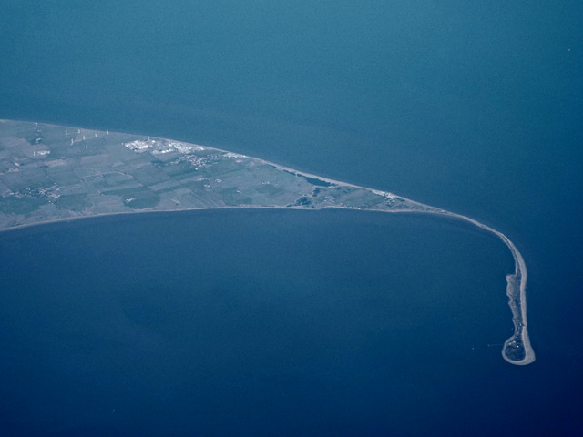
Alterations in the dominant wind and wave patterns can lead to the development of a recurved tip on a spit. With the passage of time, multiple recurved ends may take shape as waves readjust to their prevailing direction. In areas where the wind possesses enough force to carry away fine sand particles from the beach, dunes might emerge, contributing to the spit’s transformation. This transformation is further facilitated when pioneering plants, such as marram grass, anchor the sand in place.
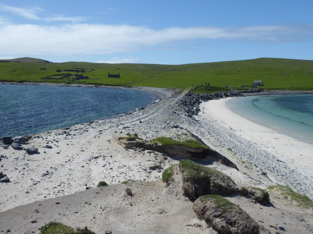
Bars and Tombolo
A bar is a type of spit that connects two headlands, and their presence becomes most noticeable during low tide when they are exposed. When the tide is high, bars cause the water to become shallower, often leading to the premature breaking of waves. In some cases, the formation of a lagoon within a bay can be attributed to the presence of a bar.
The formation of a bar
When a spit links the mainland and an island, it gives rise to a landform known as a tombolo. The picture underneath shows a sandbar at Banna Minn, Shetland Islands, Scotland.
Ridges
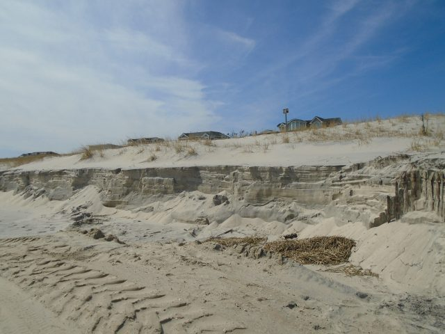
Ridges are coastal landforms shaped by the accumulation of sand transported across the beach. Sufficient sand is deposited and exposed in the intertidal zone, also known as the foreshore, which is the area situated between the high tide and low tide marks. Subsequently, wind-driven saltation carries this sand, contributing to the formation of ridges. These ridges materialize in places where the rate of beach sediment deposition surpasses that of erosion, creating a positive sediment budget.

Sand Ridges on Spurn Point
When dry sand reaches the upper part of the beach, it may become entrapped by various debris like driftwood, seaweed, rocks, and stones. If this sand is not quickly eroded, it can become a substrate for colonization by small plants or can capture other wind-blown detritus, increasing its volume and, consequently, its capacity to trap more sand. The pH of the sand in this area is alkaline due to the presence of carbonates from shells, which makes it suitable for hardy plant species like lyme grass and sand couch to establish themselves. The initial ridges that form are referred to as embryo ridges. These ridges are inhabited by species such as lyme grass, sand couch, and marram grass, which colonize by growing upward and accumulating wind-blown sand. These pioneering plants provide a crucial foundation for the ridges, making them more hospitable for later plant growth. These initial ridges typically grow to a height of about 1 meter.
The subsequent stage in the development of sand ridges involves the creation of foredunes or yellow ridges. Initially, these ridges appear yellow but darken as organic matter, or humus, is added to the sand. The ridges remain somewhat alkaline. Foredunes typically reach a height of around 5 meters, with approximately 20% of the sand exposed, a significant reduction from the roughly 80% of uncolonized embryo ridges. These foredunes have very limited moisture content.
The following stage entails the formation of grey dunes and dune ridges. At this point, the ridges become more stable. The sand becomes increasingly acidic due to the accumulation of humus, which, in turn, enhances water retention. These conditions permit the flourishing of new plant species like creeping willow and dewberry. Less than 10% of the sand is exposed on these dunes, which tend to reach heights between 8-10 meters. As sand ridges become colonized by vegetation, the plant roots stabilize the sand, preventing erosion and holding it in place. An exposed cross-section of the ridge reveals the depth of the root system.
Very little sand accumulates beyond the grey dunes and dune edges, leading to the development of wasting ridges. In this area, the sand becomes increasingly acidic, water-absorbent, and rich in humus. Typical vegetation includes heather and gorse. Ridge height in this zone usually ranges from 6-8 meters.
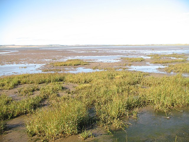
Salt swamps
Salt swamps regularly happen in protected stream estuaries or behind spits. Vegetation forms in the intertidal mudflats found in these regions.
A few coasts in tropical locales (between 30° S and 30° N) are portrayed via carbonate reefs. Reefs form in moderately shallow marine water from 200 to 300m to 2,000 to 3,000m of shore in regions where there is next to zero contribution of clastic silt from streams, and marine life forms, for example, corals, green growth, and shelled life forms can flourish. The related organic procedures are upgraded where upwelling flows bring compound supplements from deeper water (yet not all that profound that the water is colder than about 25°C) (Figure 17.24). Silt that forms in the back reef (shore side) and fore reef (seaside) are commonly commanded via carbonate pieces disintegrated from the reef and from creatures that flourish in the back-reef zone that is shielded from wave vitality by the reef.
Frequently Asked Questions
What are landforms of deposition?
Landforms of deposition are created when sediment, carried by wind, water, or ice, is deposited in a specific area, forming features like deltas, alluvial fans, and sand dunes.
How is a delta formed?
Deltas form at the mouth of a river where sediment-laden water slows down upon entering a standing body of water (like a lake or ocean), causing sediment to settle and create a fan-shaped landform.
What is an alluvial fan, and how does it form?
An alluvial fan is a fan-shaped deposit of sediment formed when a fast-flowing river or stream suddenly slows down upon entering a flat or gently sloping plain.
How are sand dunes created?
Sand dunes form when wind transports sand and deposits it in a mound or ridge shape due to changes in wind speed, direction, and the availability of sand.
What role does glacial deposition play in shaping the landscape?
Glacial deposition involves the dropping of sediment and rocks as a glacier melts and recedes. It creates landforms such as moraines, eskers, and drumlins, shaping the terrain in glaciated regions.
References
- Coastal landforms. (n.d.). Retrieved from BBC: https://www.bbc.co.uk/bitesize/guides/zxj6fg8/revision/2
- Landforms of Coastal Deposition. (n.d.). Retrieved from Opentextbc: https://opentextbc.ca/geology/chapter/17-3-landforms-of-coastal-deposition/
- Types of Depositional Landforms. (n.d.). Retrieved from Sciencing: https://sciencing.com/types-depositional-landforms-8242586.html
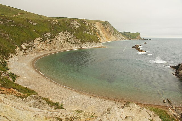
- Man ‘O War Cove
- Summer vs Winter Beach
- Long Beach, Tofino, Vancouver Island
- Beach morphology illustration
- Camber Sands, UK
- Spurn Point
- Banna Minn, Shetland Islands, Scotland
- Sand ridge
- Salt Swamp, Holy Island