


River formation and its course represent a fascinating journey of water, rock, and time. These meandering waterways, whether gentle streams or powerful torrents are the result of complex geological processes that have shaped our planet for millennia. They begin as humble springs or mountain runoff, gathering momentum as they wind their way through valleys, carving canyons, and nurturing ecosystems along their course. Understanding the formation and course of rivers is not just about geological curiosity; it’s about unravelling the dynamic forces that shape landscapes, influence ecosystems, and sustain life on Earth. As we embark on this exploration, we’ll follow the intricate journey of rivers, from their origins to their convergence with larger bodies of water, gaining insights into the profound impact they have on our planet’s geology, ecology, and human societies.
The mechanism of humid erosion
Humid erosion involves entire aspects of shaping the effects of running water from the activities of rainwater to that of the rivers.
The movement of water and the material depends on:
- Lubricating action of water due to gravity – It is highly pronounced in the areas where the slope is steep.
- Soil creep – The slow movement of matter down the slope
- The sudden movement of material occurs in areas where rainwater is the lubricating agent. For example – landslides. These landslides cause an obstruction on roads and railway lines in the mountainous areas.
The processes of river action
The river carries a lot of eroded material and forms the river’s load which can be categorised into three types –
- Materials in solution – The material or mineral which is dissolved in water is called a solution.
- Materials in suspension – When the material is too big to be dissolved, it is carried with water in the form of suspension. For example – clay, mud, silt, etc.
- The traction load – When coarser materials like pebbles, boulders and rocks are rolled along under the pressure of water, it is called the traction load as it moves with the force of friction by water.
According to estimates, for every square kilometre of the earth’s surface, around 200 tons of material in the form of a suspension and 50 tons in the form of solution are being carried off by running water every year. Half of the area of the U.S.A. is drained by the Mississippi River, which takes away more than two million tons of eroded material into the Gulf of Mexico daily. This leads to the lowering of river basins. River Irrawaddy which is located in Myanmar lowers its drainage basin by about 0.5 meters every 400 years.
During floods, the material carried by the river doubles which is why the colour of the river looks muddy during a flood.
The ability of the river to carry material depends largely on:
- The volume of the water.
- The velocity of the flow.
- Size, shape and weight of the load.
If you double the velocity of the river, the transporting power increases at least tenfold which is why the movement of even large boulders is seen during floods. Also, the movement of the seasonal rivers is intermittent. It does not remain equally active all year round. It is most active during the rainy season.
River erosion and transportation
The process of erosion and transportation goes on simultaneously in rivers comprising of the processes given below:
- Corrasion or abrasion – When river traction load is mechanically ground against the beds and banks of the river, it is called corrasion or abrasion. The rock fragments are hurled against the sides of the river and also roll along the bottom of the river. Corrasion takes place in two ways –
Lateral corrasion – The V-shaped valley is widened by the sideways erosion.
Vertical corrasion – The downward action of water that helps in increasing the depth of the river channel. - Corrosion or solution – When soluble or partly soluble rocks come in contact with water, they get dissolved by the chemical action and are carried away with water in the form of a solution. The best example of these kinds of rocks is limestone rocks which contain calcium carbonate and get easily dissolved and are moved with the water. The splashed water enters the crevices and cracks which makes way for the disintegration of the rocks. Also, the softer rocks are broken down easily when water comes in contact with these rocks. Through this process, the loose fragments of both the bed and bank get carried away with water.
- Attrition – The rolling and collision of rocks among each other causes wear and tear of these rocks. The coarse material is broken down into smaller materials, and the angular edges of the rocks are smoothed which becomes round to form pebbles. The finer substances are further carried downstream where they get deposited and form a new landform.
The course of the river
It is categorised into three distinct parts:
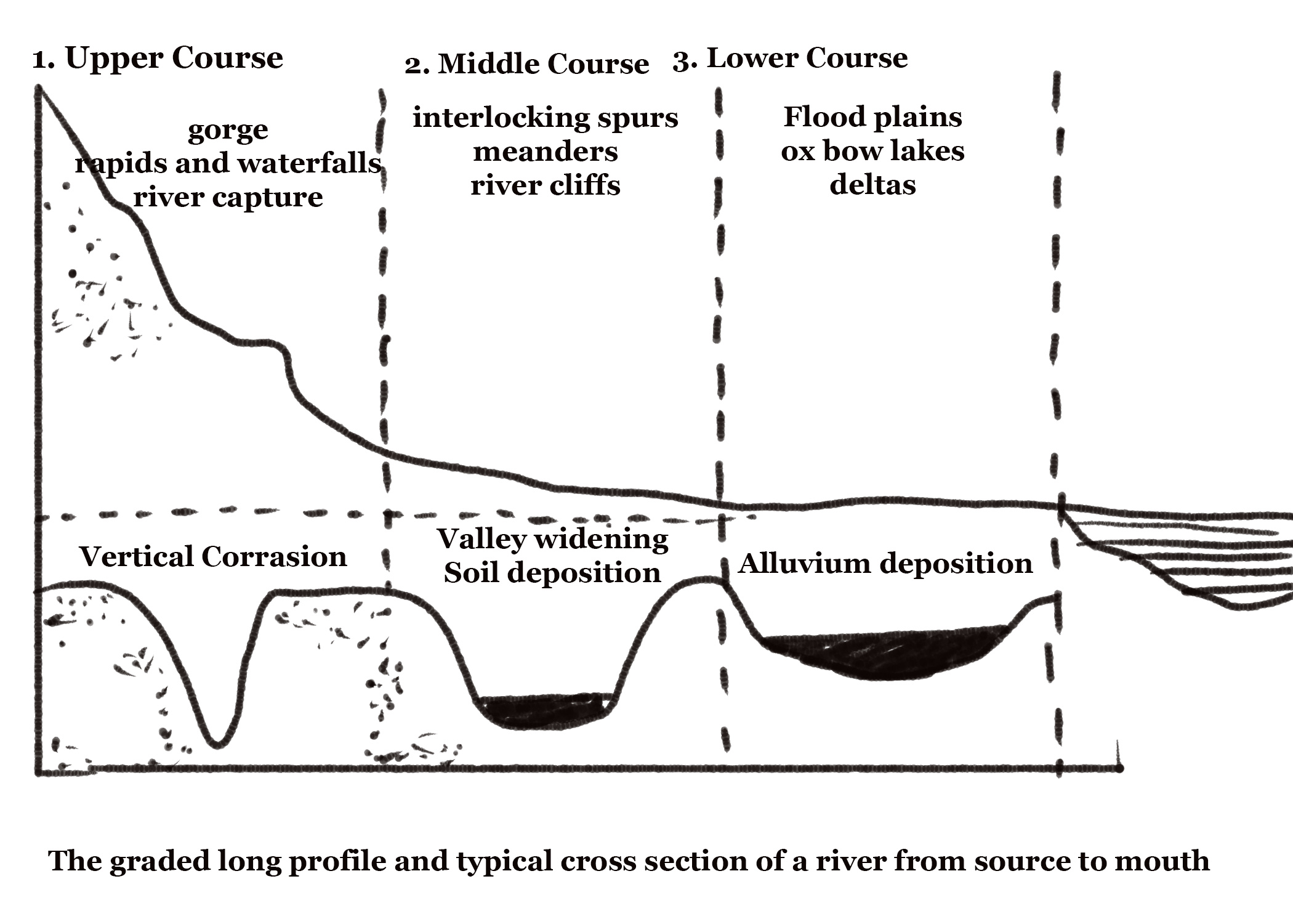
- The upper or mountain course – This starts at the source of the river near a watershed, which is usually the crest of the mountain range. The speed of the river is very fast in this portion because the slope is steep. The main action of the river is done by vertical corassion. Consequently, a narrow, deep and unique V-shaped valley is formed. Lateral corrasion gets overpowered by the pace of downward lateral cutting and hence does not play an important part. The formation of gorges occurs when the rocks are too hard and resistant. Example – the gorge formed by the Indus River in Kashmir. In arid regions, where the rainfall is very low, the narrow deep valleys are formed called canyons. For example – The Bryce Canyon, Utah, U.S.A.
- The middle or valley course – In this part of the course, the lateral corassion overtakes the vertical corrasion. The banks continuously get eroded and widen the valley to form a V-shaped valley. The confluence of tributaries in this region increases the volume of water which increases the load of the river. Some deposition of material also occurs in this region but transportation is still the main event in this region. The interlocking spurs are formed on both sides of the valley. Rainwash, landslides, soil creep and gullying eventually widen the valley.
- The lower or plain course – When the river moves downstream across a wide, level plain becomes heavy with material brought down from the upper course. The vertical corrasion is almost negligible in this area but the lateral corrasion is still active and erodes this region. In this region, deposition plays a chief role in the formation of river beds and extensive flood plains. The volume of water increases due to the joining of many tributaries to the mainstream. The heavy material is dropped and the finer material is carried to the mouth of the river. The deposited material makes the river distribute in several small channels forming a braid-like structure.
Frequently Asked Questions about River Formation and its Course
How are rivers typically formed, and what are their primary sources of water?
Rivers are formed through various processes, including rainfall, snowmelt, and the accumulation of groundwater. They are sustained by tributaries and other water sources.
Describe the stages in a river’s course, from its source to its mouth.
A river course typically includes the upper course (mountainous region), middle course (wider valley), and lower course (nearing the sea or lake).
Explain the role of erosion, transportation, and deposition in shaping a river’s features.
Erosion removes soil and rock, transportation carries sediments downstream, and deposition leads to the formation of features like riverbanks and deltas.
What is meandering, and how does it affect a river’s course and features?
Meandering is the winding path of a river. It leads to the formation of oxbow lakes, floodplains, and erosion along outer bends.
How do human activities, such as dam construction and deforestation, impact river formation and course?
Human activities can alter river flow, sediment transport, and water quality, affecting the natural course and ecosystem of rivers.