


River and drainage patterns are the sculptors of our planet’s surface, shaping landscapes with their relentless flow and carving intricate networks that crisscross continents. These dynamic waterways, from meandering rivers in lowlands to roaring torrents in mountainous terrain, tell stories of geological processes, ecological diversity, and the interconnectedness of Earth’s ecosystems. Understanding these patterns is not just a matter of scientific curiosity; it’s key to comprehending the forces that have shaped our world over millennia. As we embark on this exploration, we’ll follow the meanders, rapids, and estuaries of rivers, unravelling the geological forces that create them, exploring their ecological significance, and recognizing the vital role they play in sustaining life on Earth.
Development of the river systems
The water that comes in the form of rain is partly absorbed by the ground, and partly evaporated and some of its parts flow in the form of streams, brooks and tributaries of the river. The water flowing through the surface has the capacity to transform the earth surface through denudation.
What is denudation?
It is the general lowering of the earth surface. It occurs due to the erosion of the surface by wind, water and air. These agents take the material to the lower surface or in the sea.
However, for the erosion to take place, the weakening of the rocks is important without which the erosion is not possible. Rain, frost and wind are agents that slowly and gradually erode and weaken the rock surface leading them to further erosion and transportation. Snow and glaciers are confined to cold and temperate latitudes, winds are most efficient in the desert region and waves work on the coastlines. Only running water is an agent which has its effect in almost every region of the world, wherever it is present. Thus, running water plays a crucial role in the denudation of the surface.
Sources of river
It can be:
- A spring
- A lake
- Or a Marsh
- Or even a glacier
River patterns
The source is mostly an upland region where there is high precipitation and have steep slope through which water can run down and move forward. Therefore, uplands are said to be the catchment areas of the river.
A divide or watershed is formed at the crest of the mountain. From this divide, the rivers flow down the slope and start its journey to reach the ocean.
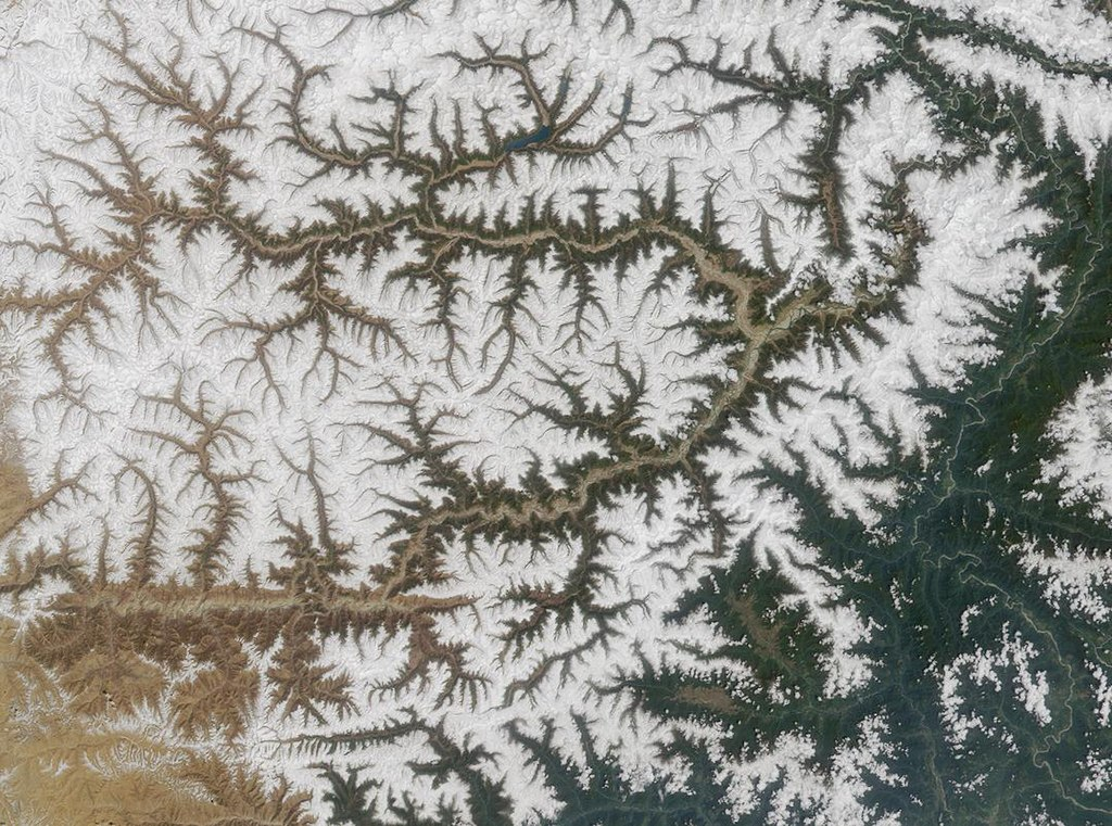
The initial and mainstream that develops due to the slope of the mountain, is called the consequent stream.
The consequent stream moves on the surface and is joined by several other streams or tributaries either at right angles or obliquely depending on the resistance offered by rocks and their alignment.
Formation of river patterns on the basis of rocks:
- Dendritic drainage – if the rocks are homogeneous in structure and offer the same resistance throughout the surface, the nearby tributaries will join the consequent tributary at an oblique angle as a subsequent stream. The pattern of drainage evolved like will appear in the shape of a tree with numerous branches. This is called dendritic drainage. Dendron means tree-like.
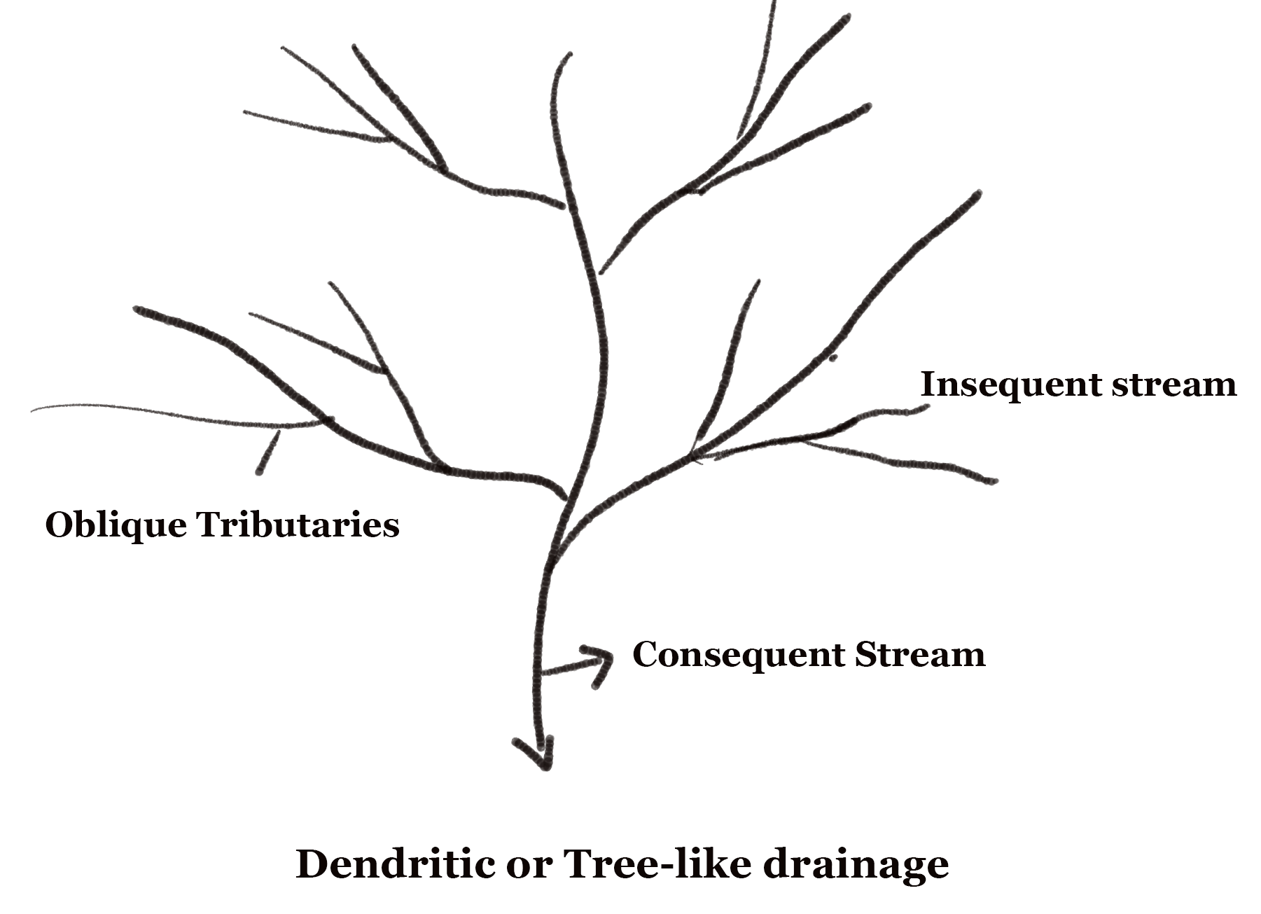
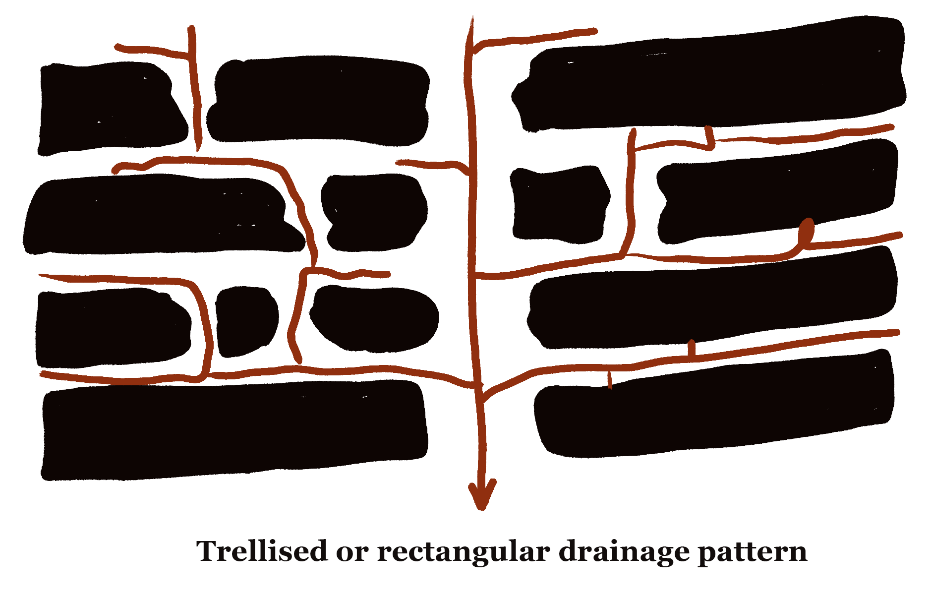
- Trellised drainage – If the rocks are not homogeneous and are made of an alternate layer of hard and soft rocks. So, when the streams join the main river by eroding the soft rocks at a right angle, it is called trellised drainage.
- Rectangular drainage – When streams join the main river through the space between the hard rocks without any erosion at a right angle, then it is called rectangular drainage. In this, the tributaries flow through faults i.e. between the spaces provided by hard rocks.
Note: Rectangular and trellis drainage can be differentiated on the basis of the spaces in streams. Rectangular drainage is formed when streams are widely spaced while trellised drainage consists of narrowly spaced streams.
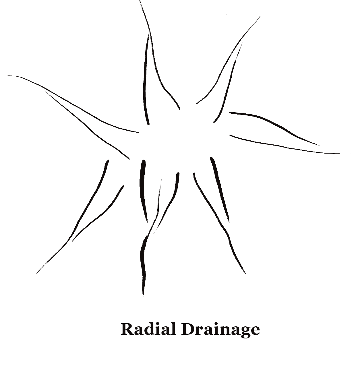
Radial drainage
When the streams move in an outward direction from a high central point, they form a radial pattern. Usually, this kind of pattern is seen in the flow of volcanoes as the lava emerges from one central point or crater. Laccoliths and domes also form radial patterns. It is formed when a stream of water flows in different directions starting from a centre point (usually a dome-like structure or a peak).
Amarkantak range, situated in India is one of the best examples of this kind of drainage pattern.
Centripetal drainage
It is almost identical to a radial drainage system. The only difference is that in radial drainage water flows out while in centripetal drainage water flows to a centre point.

Deranged drainage
It occurs in drainage basins where there is no consistent pattern of rivers and lakes. The region in which this pattern occurs is usually geologically disrupted. For example – Canadian Shield. In this area, the topsoil has been scraped off during the ice age and only bare rocks are present. Further, the melting of glaciers leads to irregular elevation of land and collection of water in low areas forming a large number of lakes. This is also the reason, there are so many lakes found in Canada. The drainage basin is at a young stage and will take time to mature and stabilize.
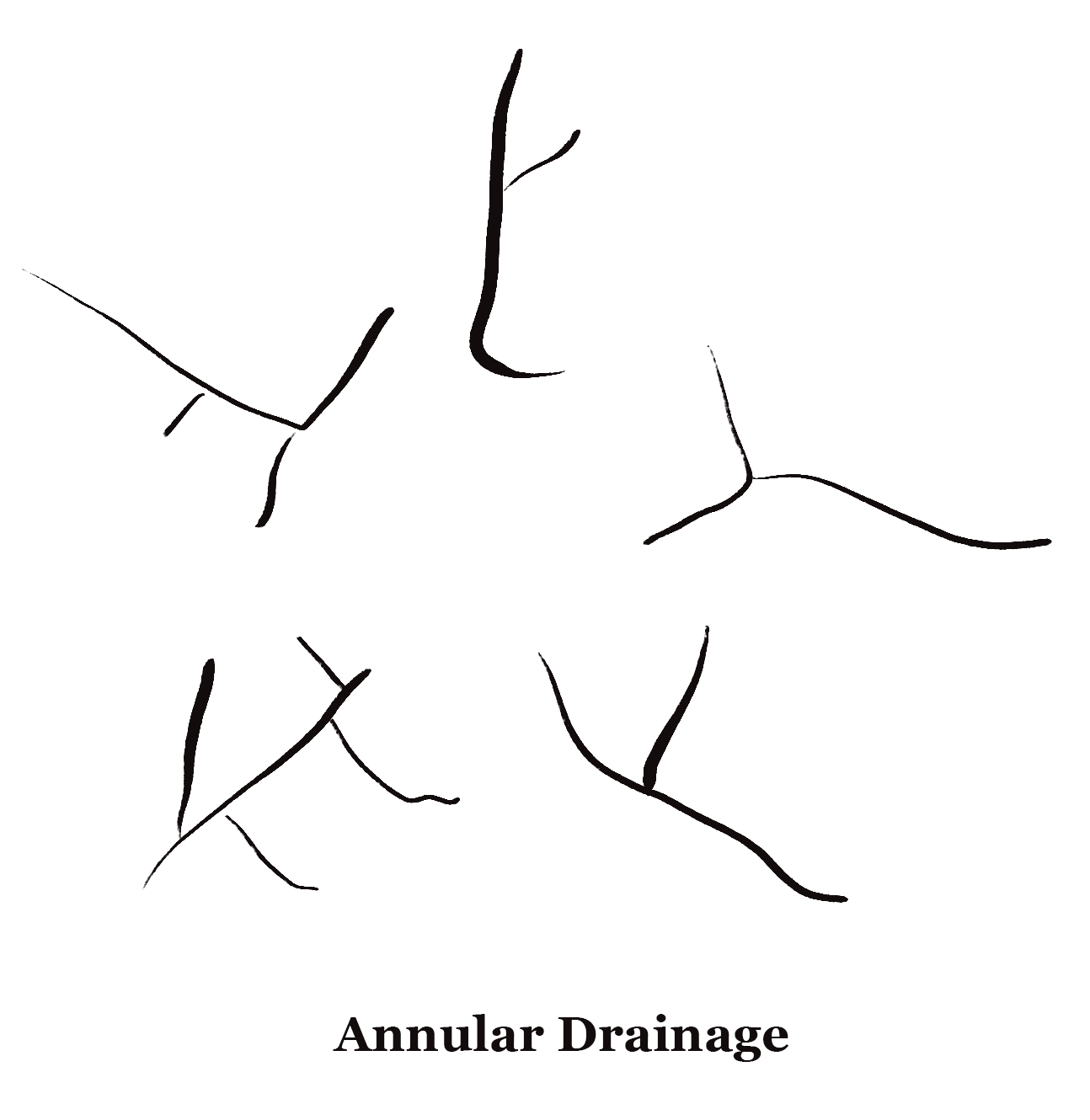
Annular drainage pattern
When streams follow a rough concentric or circular path along a belt of weak rock and form a ring-like pattern, it is called an annular drainage pattern. It can be seen in the regions where streams flow through the maturely dissected basin or structural dome where the sedimentary strata vary in hardness. The best example is the Red Valley which encircles the structure of Black Hills of South Dakota.
Angular Drainage
When streams meet the main river at acute angles due to the presence of bedrock and faults present at this angle, it is called angular drainage. The angle so formed is either more than 90 degrees or less than 90 degrees.
Discordant Drainage
When a drainage pattern is formed which does not match the topography and geology of the region, it is called a discordant drainage pattern. It is further categorised as –
- Antecedent – Both vertical erosion and upliftment of land occur with the same force.
- Superimposed – It happens in two stages. First, a drainage system appears on the surface which is composed of young rocks. The denudation process of river removes the upper surface and continues to erode it and finally reaches the old rocks.
- Ante-position – When both antecedent and superimposed drainage combine, it is called an ante-position drainage pattern.
Frequently Asked Questions About River and Drainage Patterns
What is a drainage basin, and how does it contribute to river systems?
A drainage basin is an area of land drained by a river and its tributaries. It collects water and channels it into rivers, which form the basis of river systems.
Explain the concept of a river’s watershed and its significance.
A river’s watershed is the land area from which all water drains into that river. It’s significant for understanding water resource management and conservation.
What factors influence river drainage patterns and the formation of river networks?
Topography, geology, climate, and human activities influence the formation of river networks and drainage patterns.
Describe dendritic, trellis, and radial drainage patterns and where they are commonly found.
Dendritic patterns resemble tree branches, trellis patterns have parallel main streams and radial patterns flow outward from a central point. Their occurrence depends on local geology and topography.
How can river drainage patterns impact ecosystems and human settlements?
River systems influence the distribution of vegetation, wildlife, and human communities, often providing water resources and transportation routes.