


Identifying river landscapes is a captivating endeavour that unveils the rich tapestry of Earth’s natural wonders. As we delve into the art of recognizing and understanding these distinct waterway ecosystems, we unlock the secrets hidden within each river’s unique features. From the sinuous meanders of lowland rivers to the powerful torrents of mountain streams, each landscape tells a compelling story of geological processes, ecological diversity, and the ever-evolving forces of nature. Whether you’re a passionate explorer, a budding geographer, or simply someone with a curiosity for the world’s waterways, the journey of identifying river landscapes promises to be a fascinating and enlightening adventure.
During your geography examination, you might be asked to identify some important river features on a map. We would strongly advise that you start looking at maps as quickly as possible to prepare yourself for your exam.
Identifying River Landscapes on Maps
If you are asked to identify river landforms on a map, then you could be in for quite the challenge. This is because different landforms can be found in upper courses and lower courses, meaning that you need to consider two different sets of evidence.
Landforms in the Upper Course
If you can tell that you are looking at the upper course of a river on a map, then you will know what landforms are more than likely going to be present. You can usually spot the upper course by looking for lots of contour lines, these show us that the land is steep.
It is quite normal to see waterfalls in the area around the upper course and a lot of these are marked. If there doesn’t seem to be a symbol, then you could also look for a cliff symbol and close contour lines, as these could possibly point to the presence of a waterfall.
Landforms in the Lower Course
The same goes for river landforms that can be found around the lower course, where we usually know what to look for. Most of these areas have very few contour lines because of how low the nearby land is, and the river tends to be quite thick when it reaches the lower course. It is normal to see oxbow lakes and meanders in these areas and you can also spot flood plains if you know what to look for.
Case study – The River Dee
The long profile Geographers divide a river and its valley into the upper, middle and lower course. A river’s long profile shows the height and distance downstream from the river’s source to its mouth. It is a curved shape, steeper near the source and flatter near the mouth.
Upper course
The source of the River Dee is 460 metres above sea level on the slopes of Dduallt in Snowdonia National Park, North Wales. Here the average annual rainfall exceeds 3000 mm and runoff is high from the steep upland slopes. The geology is mainly hard igneous rocks, which are very resistant to erosion. Near the source, the channel is narrow, shallow and full of angular stones, so friction with the bed and banks slows the river down. In the upper course, the river erodes vertically, cutting down into the landscape and forming a V-shaped valley with steep slopes, where processes such as sliding and slumping take place.
Middle course
As the River Dee leaves its upland area and flows downstream, the valley becomes wider and flatter, creating areas of floodplain, and its gradient decreases. The river now erodes sideways through lateral erosion as well as downwards, and there is some deposition, for example on the inside bends of meanders. Sooner or later the sediments will be eroded by the river again, so they become smaller and more rounded and transported further downstream. As more tributaries join the River Dee, its discharge increases.
Lower course
The lower course In the lower Dee Valley, the climate changes, with an average annual rainfall of less than 750 mm. The river flows through softer rocks, such as sandstones, towards Chester. Lateral erosion creates a wide valley with a flat bottom. The river channel also widens. Because it is deep and smooth, there is less friction with the river bed and banks, so the river’s velocity is greatest. More tributaries increase the Dee’s discharge. Here, lateral erosion and transportation continue and the muddy river water shows its sediment load is high. This encourages deposition, for example at the river mouth in the Irish Sea between Wales and the Wirral Peninsula. This part of the river near Chester is called the estuary because it is affected by tides.
Investigating river landscapes using OS maps
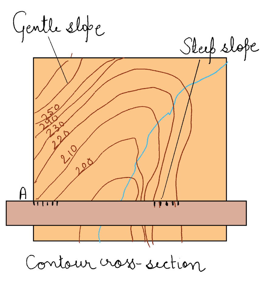
Contours are lines joining places of equal height above sea level. They also tell us how much the land slopes.
- Contours that are close together on the map show where the land slopes steeply.
- Contours further apart on the map show gentle slopes.
- Areas with few contours, or none at all, are flat: there is little or no gradient.
Drawing a cross-section through the contour lines shows what the landscape looks like figure given below:
1. Choose where you are going to make your cross-section. Place a strip of paper across the contour lines on the map.
2. Mark on the strip of paper each place where a contour line crosses it. Label the heights of the contours on your paper.
3. Make the horizontal axis the same length as your strip of paper.
4. The vertical axis is the height of the land from the lowest point to the highest point on the cross-section.
5. Use the information on your strip of paper to plot the heights on the graph paper.
6. Join the dots and label some of the landscape features
Frequently Asked Questions
What geological processes and landforms are associated with river landscapes, including river valleys, meanders, and alluvial plains?
Geological processes shape river landscapes, forming valleys, floodplains, and meandering channels.
Explain the formation of river terraces and their significance in understanding past river behaviour and landscape evolution.
River terraces are remnants of former floodplains, providing insights into river dynamics and changes in base level.
Describe the characteristics and formation of oxbow lakes, including how they develop as a result of meander cutoffs.
Oxbow lakes form when meanders are abandoned, creating curved, water-filled features separated from the main river channel.
How do waterfalls and rapids form in river landscapes, and what geological features contribute to their creation?
Waterfalls and rapids form due to variations in rock resistance and erosion, often resulting from underlying geology.
Discuss the role of sediment deposition in creating alluvial fans and deltas in river landscapes, and how these features influence local ecosystems and human activities.
Alluvial fans and deltas form when rivers deposit sediments. They provide fertile soils and support diverse ecosystems.