


Volcano
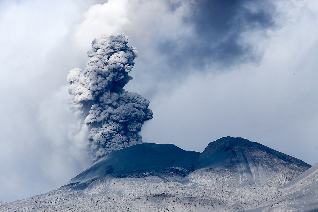
A volcano is a vent in the Earth’s crust through which molten rock erupts onto the Earth’s surface. Under the Earth’s surface, this molten rock is called magma, but once it is extruded, erupted, or flows out onto the surface, it is called lava. Volcanoes also expel various gases, ash, and solid volcanic rock.
Volcanoes usually occur as cone-shaped mountains or hills, however, they can take many other forms as well. They can be steep and rise to great heights, or low, wide, dome-shaped and spread over a large area. Studying the distribution of volcanoes tells us that they also exist as ridges beneath the surface of the sea. They are found all around our planet and on all continents, including Antarctica. There are an estimated 1,900 active volcanoes on Earth.
These volcanoes occasionally demonstrate some sort of volcanic activity and are expected to erupt again in the future. A large number of volcanoes do not pose any risk of eruption at present but may become active in the future. These volcanoes are called dormant volcanoes. Some volcanoes are inactive, and with no chance of being active in the future, are considered extinct.
Volcanic eruptions occur in a variety of ways and produce an equally varied set of landforms. When two plates collide, intense heat and pressure lead to violent eruptions that form steep, cone-shaped volcanoes. These stratovolcanoes are formed by lava that builds up after it has erupted from the opening. Conversely, when two plates pull apart, lava seeps through the space in between. In the ocean, this gentler flow of magma creates a crust on the seafloor.
Above ground, this results in wide and rounded shield volcanoes. Volcanic eruptions can at times be so violent that the upper part collapses, leaving a large pit called a caldera.
Volcanoes are powerful natural forces capable of great destruction and creation. They can eradicate whole landscapes, easily create new landforms and reshape the land. It is estimated that one out of every 20 people in the world (around 350 million) live within the ‘danger range’ of an active volcano. To better predict the onset of a volcanic eruption and to warn nearby populations of the potential volcanic hazards, volcanoes around the world are closely monitored and studied by volcanologists.
The Distribution of Volcanoes and Plate Tectonics
Volcanoes often form along the boundaries of tectonic plates. These tectonic plates are massive slabs of the Earth’s crust and upper mantle and fit together like the pieces of a jigsaw puzzle. Tectonic plates do not stay in the same position, rather they are in constant movement, albeit at the slow pace of a few centimetres a year. Tectonic plates can sometimes collide or move apart from each other.
The distribution of volcanoes over our planet’s surface is not random. Most of the Earth’s volcanoes are huddled on the edges of the continents, lining island chains, or forming long mountain ranges underneath the ocean. When observed from space, the majority of our planet’s volcanoes form linear or arcuate belts over the Earth’s surface. Scientists now consider the theory of plate tectonics as a logical explanation for the location of most volcanoes.
The Pacific “Ring of Fire”
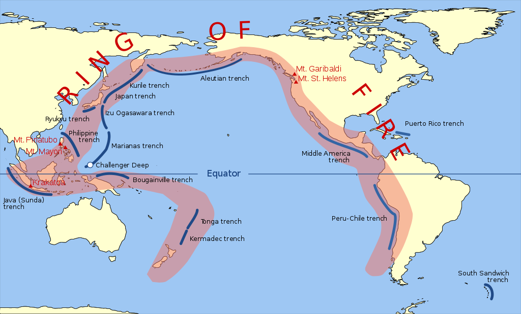
Map of the Pacific Ring of Fire
The Pacific Ring of Fire, otherwise known as the Circum-Pacific Belt, consists of multiple volcanic island arcs, mountain ranges, and tectonic plate boundaries that line the Pacific Ocean. Many of the world’s active volcanoes are found along this ring; specifically, more than 450 volcanoes that amount to 75% of the earth’s volcanoes. The Ring of Fire is approximately 40,000 kilometres in length and runs along several tectonic plate boundaries. This collection of tectonic plates includes the Pacific, Philippines, Indian-Australian, Juan de Fuca, Cocos, Nazca, and North American Plates.
The movement of tectonic plates along the Pacific Ring of Fire accounts for the large amounts of volcanoes and volcanic activity in the area. In areas called subduction zones, many plates collide and overlap at convergent boundaries along much of the Circum-Pacific Belt. In these areas, a plate that lies beneath another is pushed down and subducted by one resting on top. This action melts the subducted rock and turns it into magma.
The large amounts of magma found so close to the Earth’s surface make these subduction zones prime spots for volcanic activity. However, the same cannot be said of all parts of the Pacific Ring of Fire. One notable exception is found on the border between the North American Plate and the Pacific Plate. Here, instead of colliding, the two plates move sideways in relation to each other, creating a transform boundary. Although this type of plate boundary produces barely any volcanic activity, it generates many earthquakes and seismic activity.
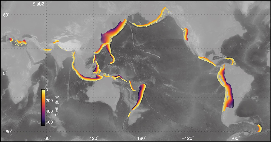
Global Map of Subduction Zones
Plate Boundaries
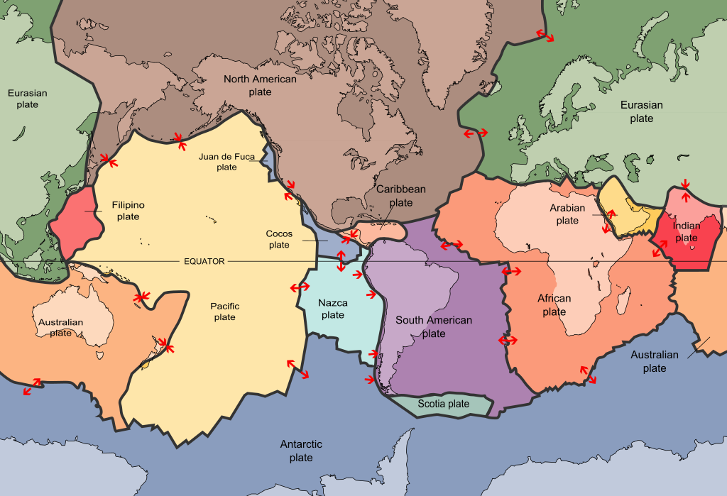
Plate boundaries are hot spots for both volcanic and seismic activity. For example, the Pacific Plate is surrounded by the earthquake zones of Japan, New Zealand, New Guinea, the Mariana Islands, the Aleutian Islands, western North America, the Pacific-Antarctic Ridge and the East Pacific Rise. At the same time, the Pacific Plate is bounded by the Pacific Ring of Fire, an area of high volcanic activity containing the majority of the world’s volcanoes.
Tectonic plates move horizontally with respect to each other at the slow rate of a few centimetres per year. The margins of two plates can form one of three basic types of plate boundary: convergent, divergent, or transform. Volcanoes can be found along with two of these types, specifically convergent and divergent plate boundaries, and are typically not found along transform plate boundaries.
Convergent Plate Boundaries

Convergent plate boundaries are created by the collision of two plates that move towards one another. This collision usually results in the denser plate edge being forced downwards and subducted. As the denser plate edge descends, the surrounding pressure and temperature increase and the mantle above the plate melt. The melted rock, or magma, then ascends through the plate, at times reaching the plate’s surface as part of a volcano. Over millennia, the magma that rises from convergent plate boundaries can create a series of volcanoes called volcanic arcs.
Most of the Earth’s volcanic arcs are located along the Pacific Ring of Fire. This series of approximately 425 active volcanoes form a horseshoe shape that straddles the borders of the Pacific Ocean. Under the ocean, a series of deep canyons, called trenches, run parallel to mountain ranges and volcanic islands that rise above the water’s surface.
For example, in the Bering Sea, the Aleutian Trench is situated parallel to the Aleutian Islands that stretch from Alaska to Russia. These landforms resulted from the Pacific Plate subducting under the North American plate. Twenty-seven of the United States’ 65 historically active volcanoes are found in the Aleutian Islands.
In South America, the Andes Mountain Range runs parallel to the Peru-Chile trench. As the Nazca plate subducts under the South American plate, these great mountains are built up continuously. The world’s tallest active volcano, Nevados Ojos del Salado, is located among the Andes Mountains. Nevados Ojos del Salado rises to almost 7 kilometres in height (6,879 metres) along the border between Chile and Argentina.
Divergent Plate Boundaries
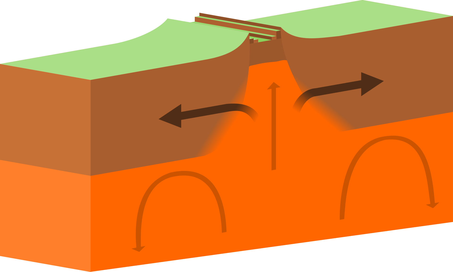
Divergent plate boundaries are found where one tectonic plate moves away from another. In this type of plate boundary, magma constantly rises from the mantle out onto the boundary. This process builds new plate material on both sides and is attributed to seafloor spreading. An example of a divergent plate boundary is the East Pacific Rise. This boundary separates the Pacific Plate from the North American, Nazca, and Cocos plates.
Another divergent plate boundary, called the Mid-Atlantic Ridge, is found in the Atlantic Ocean. It consists of the North American and Eurasian tectonic plates that are moving away from each other. As the plates move apart, hot magma rises to the surface and connects itself to the North American and Eurasian tectonic plates. As time passes, the combination of the upward movement and cooling of the magma constructs tall ridges on the ocean floor. These ridges connect to form the Earth’s longest uninterrupted volcanic mountain range almost 60,000 kilometres long.
In mid-ocean ridges, vents and fissures permit molten rock and gases to be released into the ocean. The majority of submarine volcanoes are located in these ridges. Per annum, 75% of the average volume of magma that reaches the Earth’s surface is attributed to this submarine volcanic activity. These ocean ridges can also rise above the surface of the ocean in landforms.
Divergent plate boundaries can also be observed on land. An example of this is the East African plate, a single tectonic plate that is being split in two. To the west, is what is sometimes called the Nubian Plate, which includes much of the African plate at present. To the east is the Somali plate, which includes the Horn of Africa and the Western Indian Ocean. The volcanoes Mount Kilimanjaro in Kenya and Mount Nyiragongo in the Democratic Republic of Congo are found along this divergent plate boundary.
Hot Spots
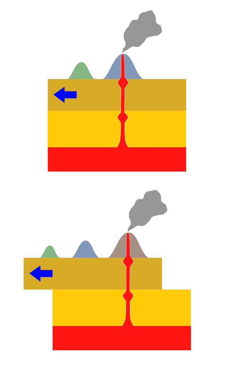
Although uncommon, some volcanoes also exist thousands of kilometres away from tectonic plate boundaries. Many scientists through the years have attempted to explain this phenomenon; however, the prevailing theory is the one proposed by Canadian geophysicist Tuzo Wilson in 1963. Wilson posits that the existence of these volcanoes can be attributed to the presence of hot spots deep below the Earth’s mantle. On their own, these areas of remarkably high temperatures can melt the tectonic plate above and create magma that erupts onto the plate’s surface.
The tectonic activity caused by hot spots below the ocean can create masses called volcanic mounds. Over millennia, these mounds can grow in size and eventually rise above sea level to create a volcanic island. Over time, the island moves along with its tectonic plate. However, the hot spot remains in its original place.
Once the volcano moves too far away from the hot spot, it becomes extinct and eventually erodes back into the sea. Over the hot spot, a new volcano will once again emerge and develop. This process continues, resulting in a perpetual cycle of volcanism. Gradually, a chain of volcanic islands traces the tectonic plate’s movement over millions of years.
On land, the presence of hot spots can also result in the creation of terrestrial volcanoes. One example is the Yellowstone Supervolcano, situated over a hot spot in the centre of the North American tectonic plate. The hot springs, geysers, and other geologic activity found in Yellowstone National Park are largely thanks to this hot spot. In the past, the Yellowstone hot spot has created a string of ancient volcanoes, which now exist as the calderas that spread across southern Idaho.
At present, some data exists in support of the hot spot theory. However, more recent scientific studies suggest that hot spots may be found in the Earth’s mantle at much shallower depths than initially theorised. Additionally, these studies also suggest that hot spots do not remain fixed at one point and may move over periods of geologic time.
Frequently Asked Questions
How are volcanoes distributed around the world?
Volcanoes are typically concentrated along tectonic plate boundaries, including divergent boundaries (mid-ocean ridges), convergent boundaries (subduction zones), and hotspot regions.
Which regions have a high concentration of volcanoes?
Some regions with a high concentration of volcanoes include the Pacific Ring of Fire, which encircles the Pacific Ocean, as well as volcanic island chains such as the Hawaiian Islands, the Aleutian Islands, and the Indonesian archipelago.
Are there any active volcanoes on the continents?
Yes, there are active volcanoes on various continents. For example, Mount Etna in Italy, Mount St. Helens in the United States, Mount Fuji in Japan, and Mount Kilimanjaro in Tanzania are well-known active volcanoes.
Why are volcanoes often found along subduction zones?
Subduction zones involve the collision of tectonic plates, where one plate descends beneath another. This process can cause the subducting plate to melt, leading to the formation of magma and volcanic activity.
Are all volcanic eruptions associated with visible volcanoes?
No, not all volcanic eruptions are associated with visible volcanoes. Some volcanic eruptions can occur underwater, resulting in the formation of submarine volcanoes or even creating new islands or seamounts.
Resources
Plate Tectonics and Volcanic Activity. (n.d.). Retrieved from National Geographic: https://www.nationalgeographic.org/article/plate-tectonics-volcanic-activity/
Ring of Fire. (n.d.). Retrieved from National Geographic: https://www.nationalgeographic.org/encyclopedia/ring-fire/
Volcano. (n.d.). Retrieved from Britannica:
https://www.britannica.com/science/volcano
Volcanoes. (n.d.). Retrieved from National Geographic: https://www.nationalgeographic.org/media/volcano-satellite-images/
Volcanoes, explained. (n.d.). Retrieved from National Geographic: https://www.nationalgeographic.com/environment/article/volcanoes
Volcanoes and the Theory of Plate Tectonics. (n.d.). Retrieved from United States Geological Survey https://pubs.usgs.gov/gip/volcus/page06.html