


Earthquake
An earthquake is an abrupt shaking of the ground as a result of seismic waves travelling through the earth. When masses of rock experiencing stress and strain against each other suddenly fracture and slip, large amounts of energy stored in the Earth’s crust is released as seismic waves. Earthquakes mostly occur in narrow zones called geologic faults. Here, rock masses move in relation to one other, either clashing together, pulling apart, or sliding past each other. The Earth’s major fault lines can be found at the margins of tectonic plates, which affect the distribution of earthquakes. These massive slabs of rock fit together like puzzle pieces to make up our planet’s crust.
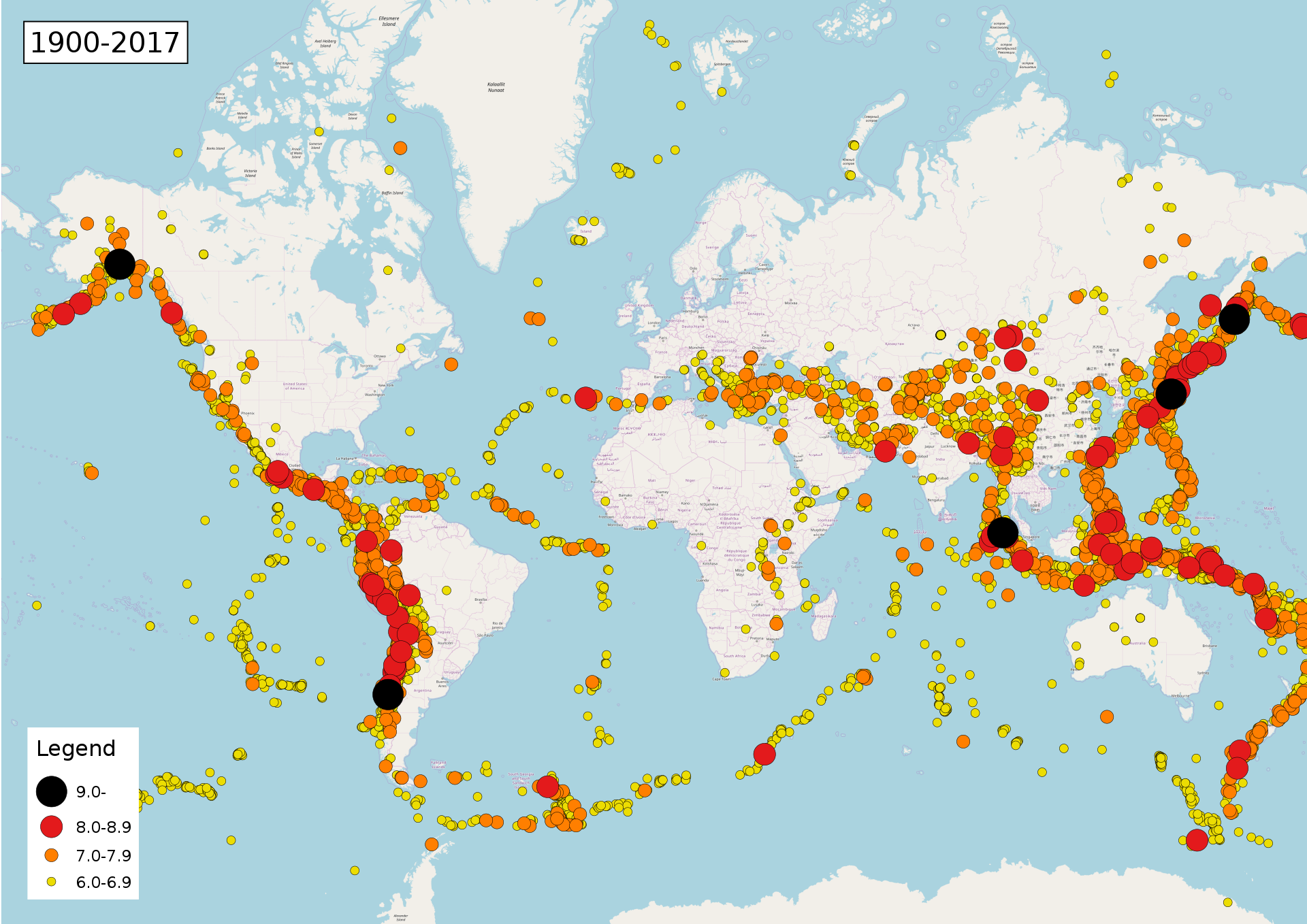
Throughout the centuries, earthquakes have resulted in the loss of countless lives and the destruction and damaging of property. Within a year, around 50,000 earthquakes are large enough to be felt without the aid of seismic instruments. It is estimated that 100 of these earthquakes are capable of causing significant damage if their epicentres were near areas with human populations. On average, one powerful earthquake happens per year.
Earthquakes and Plate Tectonics
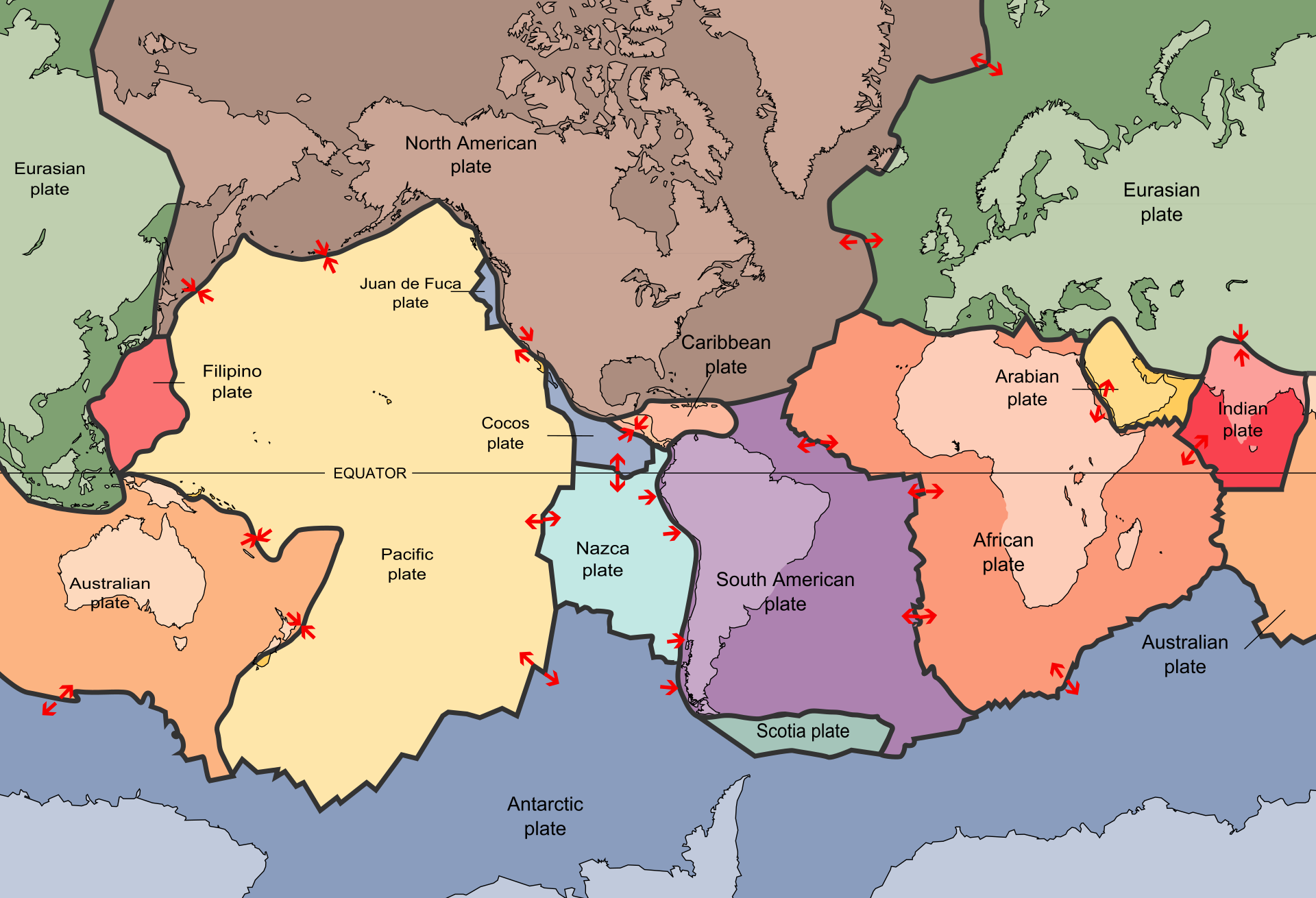
The distribution of earthquakes throughout the planet is far from random. Earthquakes tend to happen in distinct zones found at the edges of tectonic plates. These zones are called plate boundaries.
Earthquakes may also occur in areas called intraplate regions. These earthquakes may be related to stress built up by continental rifting or stress transfer from other regions. The origins of some of these earthquakes are unclear and not well understood. The Great Rift Valley area in Africa, the Lake Baikal area in Russia, and the Tibet region in China are examples of intraplate earthquake regions.
Plate Boundaries
Plate boundaries are hot spots for both volcanic and seismic activity. For example, the Pacific Plate is surrounded by the earthquake zones of Japan, New Zealand, New Guinea, the Mariana Islands, the Aleutian Islands, western North America, the Pacific-Antarctic Ridge and the East Pacific Rise. Tectonic plates move horizontally with each other at the slow rate of a few centimetres per year. Along the margins of two plates, they can form one of three basic types of plate boundary: convergent, divergent, or transform. Earthquakes usually occur in areas near convergent plate boundaries and divergent plate boundaries.
Convergent Boundaries

Convergent plate boundaries are created by the collision of two plates that move towards one another. This collision usually results in the denser plate edge being forced downwards and subducted. As the denser plate edge descends, the surrounding pressure and temperature increase and the mantle above the plate melt. Ocean trenches and andesite volcanoes can be found above these subduction zones. The subduction zones found in convergent boundaries are often the sources of many large and deep earthquakes. Convergent plate boundaries facilitate the creation of continental crust and the destruction of oceanic crust.
Earthquakes of immense size and strength are common to convergent boundaries. All of the world’s largest earthquakes – those with a magnitude of M9 or higher – happen at the subduction zones at convergent boundaries. This is because, in comparison to steep transform boundaries, those that dip gently potentially have rupture zones of greater widths.
In convergent boundaries where two continental plates collide, neither can be subducted. These areas are called mountain-building convergent plate margins. Mountain ranges such as the European Alps and the Himalayas are examples of mountains built from this type of convergent boundary.
Divergent Boundaries
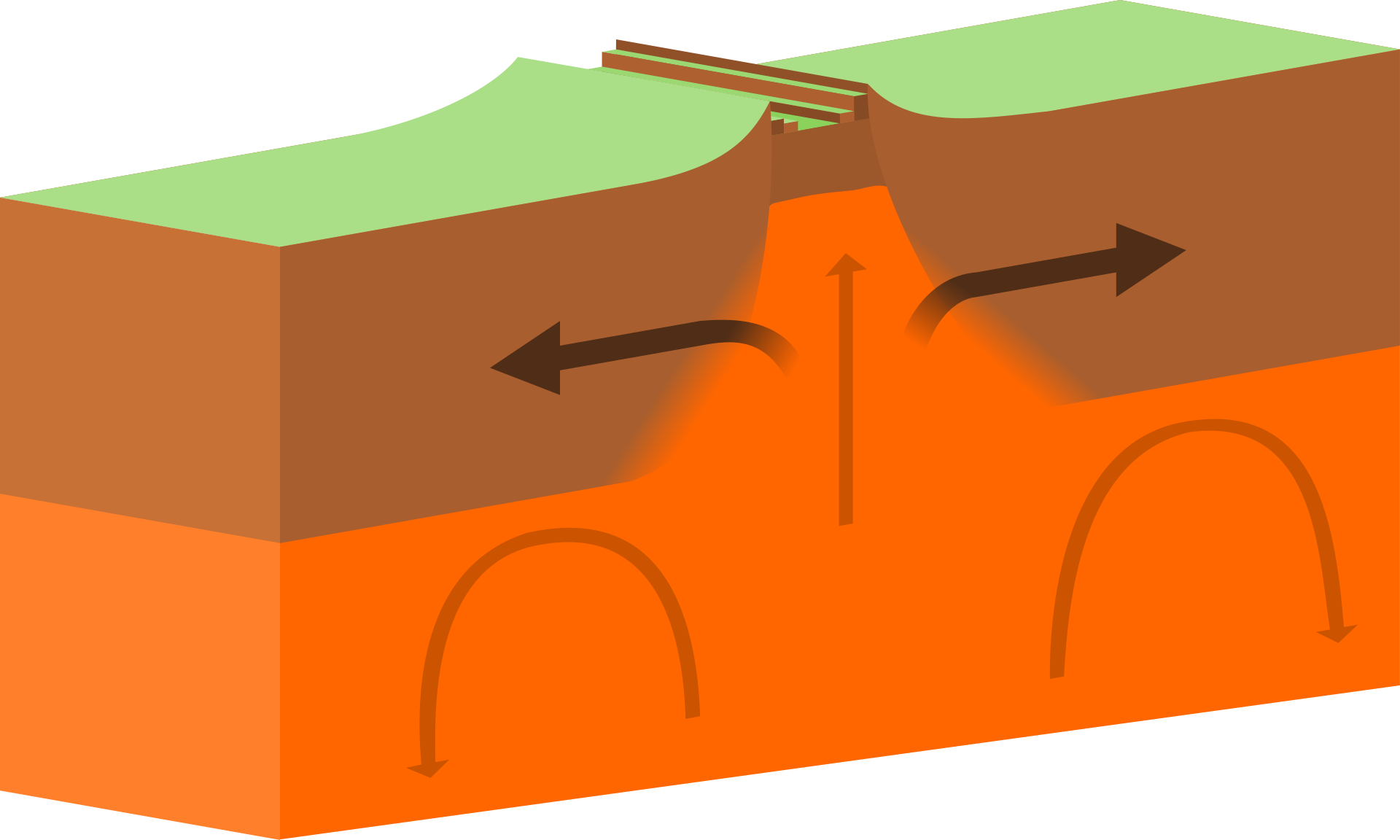
Divergent plate boundaries are found where one tectonic plate moves away from another. In this type of plate boundary, magma is constantly rising from the mantle out onto the boundary. This process builds new plate material on both sides and is attributed to seafloor spreading. Earthquakes are rare along spreading segments. Due to the high rock temperatures in the areas where spreading occurs, the small number of earthquakes are small and infrequent.
An example of a divergent plate boundary is the East Pacific Rise. This boundary separates the large Pacific Plate from the North American, Nazca, and Cocos plates. Earthquakes are common in divergent boundaries such as the mid-Atlantic Ridge and the East Pacific Rise. However, these geologic events are limited to 30 kilometres in depth at narrow zones near the ridge itself.
Divergent plate boundaries can also be observed on land. An example of this is the East African plate, which is a single tectonic plate that is being split into two. To the west, is what is sometimes called the Nubian Plate, which includes much of the African plate at present. To the east is the Somali plate, which includes the Horn of Africa and the Western Indian Ocean. The volcanoes Mount Kilimanjaro in Kenya, and Mount Nyiragongo in the Democratic Republic of Congo are found along this divergent plate boundary.
Transform Boundaries
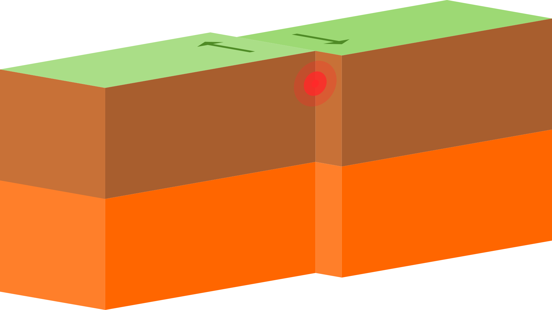
Transform boundaries are marked by the presence of two plates that slide past each other. Earthquakes are common along these geologic faults. However, unlike convergent and divergent boundaries, new crust is not created nor old crust destroyed. Instead, crust found in transform boundaries experiences cracking and breaking. As the two opposing plates slide past each other, the rocks along the margins are crushed and pulverised. At submarine depths, this creates an undersea canyon, however on land, this forms a linear fault valley. The largest earthquakes on transform boundaries are recorded around the magnitude of M8. One famous example of a transform boundary is the San Andreas Fault in California, United States of America.
Earthquake Belts
Earthquakes may occur at any location at any time. However, it has been observed that earthquakes typically follow the same patterns every year. These happen in our planet’s three large zones called earthquake belts.
Other seismic shocks may occur in other areas of the world, outside of these three earthquake belts. These shocks can be just as devastating; however, they do not happen as frequently. Many years usually pass between shocks.
Circum-Pacific Seismic Belt
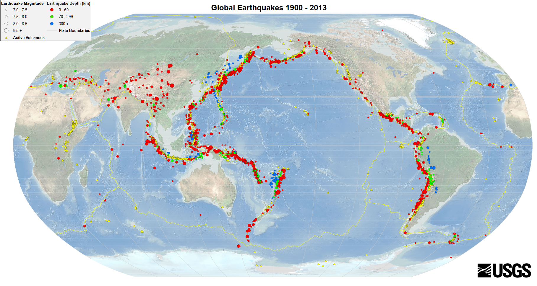
The Circum-Pacific Seismic Belt, otherwise known as the Pacific Ring of Fire, is the world’s largest earthquake belt. Located along the edges of the Pacific Ocean, this is where around 81% of all the earth’s earthquakes occur. Many populated coastal regions near the Pacific Ocean, such as Japan, New Zealand, New Guinea, Alaska, the western coasts of North and South America, and the Aleutian Islands. An estimate of 80% of the energy released in earthquakes at present comes from earthquakes that have epicentres in this area. The Circum-Pacific Seismic Belt is bounded by multiple tectonic plates. The majority of which are plates of oceanic crust that are sinking beneath another plate in areas named subduction zones. In these subduction zones, earthquakes are caused by a slip between different plates and rupture within the same plate. Seismic activity is not uniform throughout the Cricum-Pacific Seismic Belt. Many points in the belt have a number of branches. The M9.5 Chilean Earthquake in 1960 and the M9.2 Alaska Earthquake in 1964 are examples of two powerful earthquakes that came from this region.
Alpide Earthquake Belt
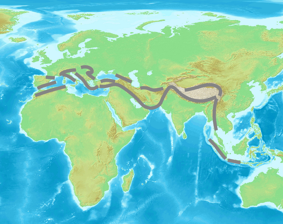
Extending from Java to Sumatra, passing through the Himalayas, the Mediterranean Sea, and finally going out into the Atlantic, the Alpide Earthquake Belt is where 17% of the world’s largest and most destructive earthquakes occur. This includes the M7.6 shock in Pakistan that killed over 80,000 in 2005 and the M9.1 Indonesia earthquake which caused a tsunami that tragically took the lives of more than 230,000 individuals. An estimated 15% of the world’s total energy released by earthquakes comes from this earthquake belt.
Mid-Atlantic Ridge
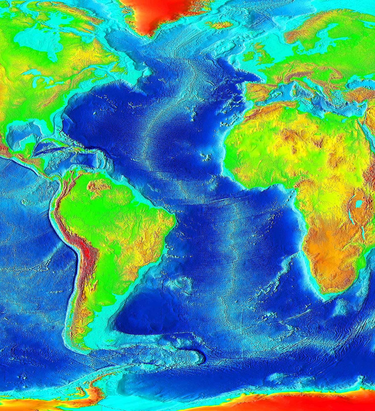
Lying mostly underwater, the Mid-Atlantic Ridge is submerged far from human settlements. However, Iceland is situated directly above the Mid-Atlantic Ridge and has experienced many large earthquakes, with at least a magnitude of 6.9.
Earthquakes in the UK
The United Kingdom itself is situated relatively far from the nearest plate boundary, the Mid-Atlantic Ridge. However, earthquakes still occur in the region as the result of movement on pre-existing fault planes and the release of crustal stress within tectonic plates. It is difficult to pinpoint the exact forces that drive earthquake activity in the United Kingdom. Possible explanations include regional compression brought upon by the movement of tectonic plates and uplift caused by melting ice sheets that, a thousand years ago, covered many parts of Britain.
The number of earthquakes detected and located in the UK ranges from 200–300 per year. Of this number, around 20–30 are perceptible, while the remaining few hundred are only detected by specialised seismic instruments. The majority of earthquakes in the United Kingdom are small in size and don’t result in damage. Although some UK earthquakes cause significant damage, this is not much compared to the larger earthquakes that devastate other sectors of the world. It is estimated that the United Kingdom experiences a magnitude 4 earthquake every two years, while a magnitude 5 earthquake occurs every 10–20 years. As research suggests, the largest earthquake that could occur in the United Kingdom would have a magnitude of about 6.5.
Location of Earthquakes in the UK
Most of the United Kingdom’s earthquakes occur on the western side of Great Britain. The North Sea experiences significantly more earthquakes than the British mainland. In comparison, there are little to no earthquakes in the northeast of England and the east of Scotland. Virtually no earthquakes happen in Ireland.
Notable UK Earthquakes
The largest recorded British Earthquake, with a magnitude of 6.1, happened near Dogger Bank in 1931. The earthquake occurred 60 miles offshore yet still caused minor damages to infrastructure on England’s eastern coast. On the other hand, the UK earthquake that had caused the most damage happened in the vicinity of Colchester in 1884. This earthquake damaged around 1,200 buildings, leaving cracked walls, collapsed chimneys, and in great need of repair.
Frequently Asked Questions
Where are the most earthquake-prone areas in the world?
The Pacific Ring of Fire is the most earthquake-prone region, encompassing the coasts of the Pacific Ocean, including countries like Japan, Chile, and Indonesia.
Are there any areas that are relatively free from earthquakes?
No place on Earth is entirely free from earthquakes, but areas located far from tectonic plate boundaries, such as the interior of continents, generally experience fewer seismic activities.
Why do earthquakes frequently occur along plate boundaries?
Earthquakes occur along plate boundaries due to the movement and interaction of tectonic plates. When plates collide, slide past each other, or separate, it creates stress on the Earth’s crust, leading to earthquakes.
Do earthquakes occur underwater as well?
Yes, earthquakes can occur underwater. In fact, a significant number of earthquakes happen along the oceanic plate boundaries, such as the subduction zones, where one plate sinks beneath another.
Which country experiences the most frequent earthquakes?
Japan experiences the most frequent earthquakes among all countries. Its location along the Pacific Ring of Fire makes it highly prone to seismic activities.
Resources
Earthquake. (n.d.). Retrieved from Britannica: https://www.britannica.com/science/earthquake-geology/Tectonics
Earthquake. (n.d.). Retrieved from National Geographic: https://www.nationalgeographic.org/topics/resource-library-earthquake/?q=&page=1&per_page=25
Earthquakes. (n.d.). Retrieved from BBC: https://www.bbc.co.uk/bitesize/guides/zg9h2nb/revision/1
Earthquakes. (n.d.). Retrieved from Geohazards: http://geohazards.massey.ac.nz/earthquakes/distribution_e.html
Earthquakes and Plate Tectonics. (n.d.). Retrieved from BCampus: https://opentextbc.ca/geology/chapter/11-2-earthquakes-and-plate-tectonics/
Plate Tectonics and the Ring of Fire. (n.d.). Retrieved from National Geographic: https://www.nationalgeographic.org/article/plate-tectonics-ring-fire/
What are the different types of plate tectonic boundaries?. (n.d.). Retrieved from NOAA: https://oceanexplorer.noaa.gov/facts/plate-boundaries.html
Where do earthquakes occur?. (n.d.). Retrieved from United States Geological Survey: https://www.usgs.gov/faqs/where-do-earthquakes-occur?qt-news_science_products=0#qt-news_science_products
Where do earthquakes occur?. (n.d.). Retrieved from British Geological Survey: https://www.bgs.ac.uk/discovering-geology/earth-hazards/earthquakes/where-do-earthquakes-occur/