Introduction to Glaciated Landscapes
Glaciated landscapes are some of the most awe-inspiring and beautiful natural features on our planet. They are the result of the immense power of glaciers, which carve their way through rocks and reshape entire regions over thousands of years. Glaciers have left their mark on almost every continent, from the icy expanses of Antarctica to the rugged peaks of the European Alps. In this A-level article, we will explore the processes that create glaciated landscapes, and examine the landforms and features that result from glacial erosion, deposition and meltwater activity. We will also consider the ways in which glaciation has influenced human history, from the settlement patterns of early humans to the development of tourism and recreation in glaciated regions today. By the end of the article, students will have a deep understanding of the unique beauty and scientific significance of glaciated landscapes, and the important role they play in shaping the world around us.
What is a Glaciated Landscape?
Glaciated landscapes are regions that have been shaped by the activity of glaciers. Glaciers are large masses of ice that form in areas where snowfall exceeds snowmelt over many years. As more snow accumulates, it compresses into ice, which begins to flow downhill under its own weight. This movement of ice over time can erode the underlying rock and shape the landscape in a variety of ways.
Glaciated landscapes can be characterized by a number of landforms and features that result from glacial activity. These include:
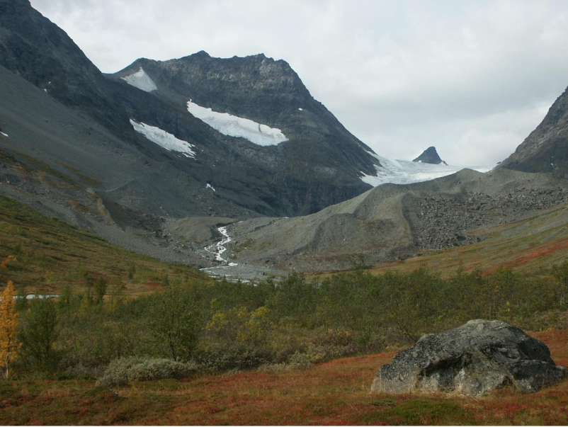
- U-shaped valleys: These valleys are characterized by steep, straight sides and a flat bottom. They form as glaciers move downhill, eroding the valley floor and carving the sides of the valley into a U-shape.
- Cirques: These are bowl-shaped depressions that form at the head of a glacier where it begins to erode the surrounding rock. They are often surrounded by steep cliffs and may contain a small lake or pond.
- Horns: These are sharp peaks that form when several cirques erode into a single mountain peak.
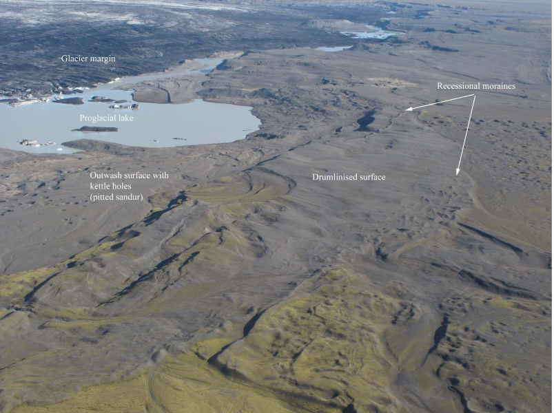
- Moraines: These are ridges of rock and debris that are deposited by glaciers as they move. They can be lateral (along the sides of a glacier), medial (formed when two glaciers merge), or terminal (at the end of a glacier).
- Glacial erratics: These are large boulders that are transported by glaciers and deposited far from their original location.
Processes that create Glaciated Landscapes
Glaciated landscapes are formed through a combination of glacial erosion, deposition, and meltwater activity. Glaciers are large masses of ice that form when snow accumulates and compacts over many years. When these glaciers move, they can erode the land beneath them through two main processes: plucking and abrasion.
Plucking occurs when the glacier freezes onto rocks and pulls them out of the ground as it moves. This process can create steep-sided valleys, called U-shaped valleys, which are often found in glaciated regions. Abrasion occurs when the glacier scrapes against the land, wearing it down over time. This process can create long, winding ridges called moraines.
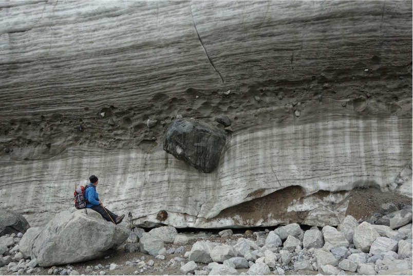
Glaciers also deposit material as they move. As the glacier melts, it can leave behind rocks, soil, and other debris. These deposits can create landforms such as drumlins, which are elongated hills that are often found in groups, eskers, which are winding ridges of gravel and sand, and erratics, which are large boulders transported far distances from their origins.
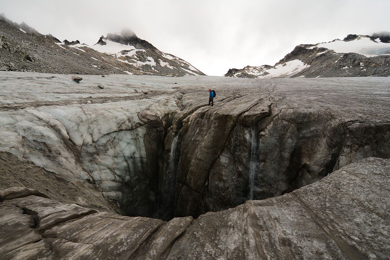
Finally, meltwater produced by glaciers can create unique landforms and features. For example, as the meltwater flows through the glacier, it can create long tunnels called moulins. When the water exits the glacier, it can form steep-sided valleys called meltwater channels. Meltwater can also create lakes, ponds, and rivers in glaciated regions.
Landforms and features found in glaciated landscapes
Glacial erosion, deposition, and meltwater activity create a variety of distinctive landforms and features in glaciated landscapes.
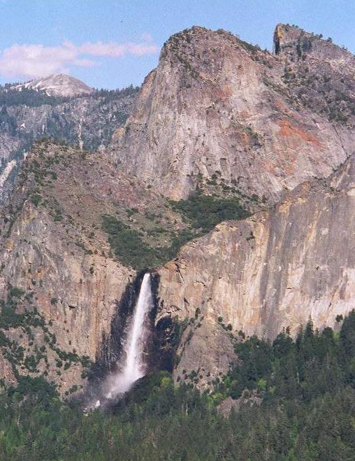
Glacial erosion can create deep, steep-sided valleys called U-shaped valleys. These valleys are formed by the plucking and abrasion of the glacier as it moves over the land. They often have a flat bottom and steep sides, and may contain glacial lakes or rivers. Cirques are bowl-shaped hollows at the head of U-shaped valleys, where the glacier originated. Arêtes are sharp ridges formed between two cirques.
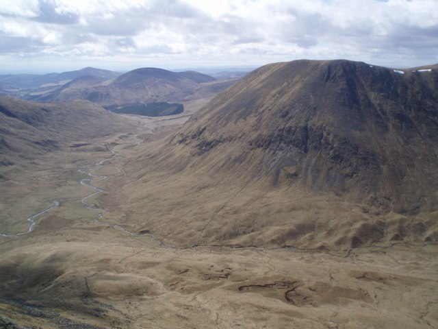
Glaciers can also create hanging valleys, which occur when a smaller tributary glacier joins a larger valley glacier. The smaller glacier has less erosive power and thus erodes less deeply, creating a valley that “hangs” above the main valley.
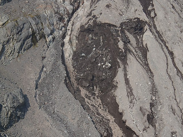
Glacial deposition occurs when the glacier deposits sediment as it melts. This sediment can form a variety of landforms, including moraines, drumlins, eskers, and kames. Moraines are ridges of glacial till left behind by a glacier’s leading edge, and can be lateral (along the side of the glacier), medial (between two glaciers), or terminal (at the end of the glacier). Drumlins are elongated hills that are often found in groups and are streamlined in the direction of ice flow. Eskers are winding ridges of gravel and sand that were deposited by meltwater streams flowing beneath the glacier. Kames are cone-shaped mounds of sand and gravel that form when sediment is deposited on the surface of a stagnant glacier.
Meltwater activity can also create distinctive landforms and features. Moulins are long, vertical shafts that form when meltwater drains through a hole in the glacier’s surface and carves a tunnel through the ice. When the water exits the glacier, it can form steep-sided valleys called meltwater channels. Meltwater can also create lakes, ponds, and rivers in glaciated regions.
Human Relationship with Glaciated Landscapes
Glaciation has had a significant impact on human history, from the settlement patterns of early humans to the development of tourism and recreation in glaciated regions today. Here are some of the ways that glaciation has influenced human history:
- Settlement patterns of early humans: During the last Ice Age, which began around 2.6 million years ago and ended approximately 12,000 years ago, large areas of the Earth’s surface were covered in ice. This had a major impact on the migration and settlement patterns of early humans, who had to adapt to changing climate conditions and shifts in the availability of resources. For example, as the ice sheets expanded and contracted, they created land bridges that allowed early humans to migrate across continents.
- Agriculture and Civilization: Glaciation also played a role in the development of agriculture and civilization. As the ice receded, the climate in some areas became more suitable for farming, allowing early humans to settle and form communities. For example, the Fertile Crescent in the Middle East, which includes modern-day Iraq and Syria, was once covered by glaciers. As the glaciers receded, the climate became more favorable for agriculture, which led to the development of some of the earliest civilizations in human history, such as Sumer and Babylon.
- Economic development: Glaciation has also had a significant impact on economic development, particularly in regions with large mountain ranges and glaciers. Glaciers can act as a source of freshwater, which is essential for agriculture, industry, and human consumption. In addition, glaciers can provide hydropower for generating electricity. Many countries have developed extensive hydroelectric power systems based on their glaciated mountain ranges.
- Tourism and recreation: Glaciated regions are often popular tourist destinations, attracting visitors from around the world who come to ski, hike, climb, and explore. Glaciers and their associated landscapes can provide a stunning backdrop for outdoor activities, and their unique geological features can provide opportunities for scientific study and exploration. However, as climate change accelerates and glaciers retreat, some of these regions are facing significant challenges in terms of the impacts of tourism and the sustainability of their economies.
- Geological and environmental research: Glaciers also offer important insights into the geological history of the Earth and the impacts of climate change. As glaciers retreat, they reveal previously hidden landscapes and geological features, providing valuable data for scientists studying Earth’s history and current environmental changes. In addition, glaciers can also be used as natural laboratories for studying the impacts of climate change on water resources, ecosystems, and human societies.
More about Glaciated Landscape Models
Glacier development and mass parity
Glacier development and mass parity are terms used to describe the dynamics of glaciers, which are large masses of ice that flow downhill under their own weight over long periods of time.
Glacier development refers to the process by which a glacier grows over time. Glaciers form when snow accumulates over many years and compresses into ice. As more snow falls and compacts, the glacier becomes thicker and larger. This process can take hundreds or thousands of years, and is influenced by factors such as temperature, precipitation, and topography.
Mass parity, on the other hand, refers to the balance between the accumulation and loss of ice mass in a glacier. When a glacier is in mass parity, the amount of ice that it accumulates each year through snowfall is equal to the amount of ice that it loses each year through melting or calving (the breaking off of icebergs from the glacier). This balance is important because it determines whether a glacier will grow or shrink over time.
If a glacier is in positive mass parity, it is gaining ice mass and will grow larger over time. If it is in negative mass parity, it is losing ice mass and will shrink. In recent years, many glaciers around the world have been experiencing negative mass parity due to global warming and other factors. This has led to concerns about rising sea levels and other impacts on the environment and human communities.
Thermal system
A thermal system in glaciated landscapes refers to the way that heat is transferred through the different components of the landscape, including ice, snow, rock, soil, and water. The movement of heat is important in shaping the landscape and determining how glaciers and other forms of ice behave over time.
In a thermal system, heat is transferred through a process called conduction, which is the movement of heat from warmer objects to cooler objects through direct contact. For example, when a glacier sits on top of rock or soil, heat is transferred from the ground to the ice through conduction. This can cause the glacier to melt and form meltwater that flows into rivers and streams.
In addition to conduction, heat can also be transferred through other processes such as convection, which is the movement of heat through fluids such as water and air, and radiation, which is the transfer of heat through electromagnetic waves such as sunlight.
The thermal system in glaciated landscapes is complex and depends on a variety of factors, including the temperature and composition of the different landscape components, the amount of solar radiation that the area receives, and the amount of heat that is generated by the movement of water and ice within the landscape. Understanding these factors is important for predicting how glaciers and other forms of ice will behave in the future, and for managing the impacts of climate change on glaciated landscapes and the communities that depend on them.
Mechanisms of a glacial stream
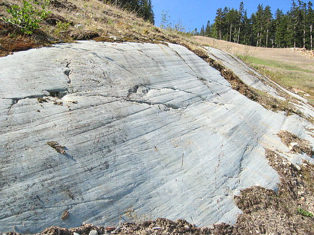
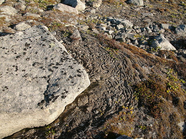
Warm-based glaciers are characterized by basal processes, such as basal sliding, which causes them to advance at a faster rate and develop distinctive features like striations (figure 1).
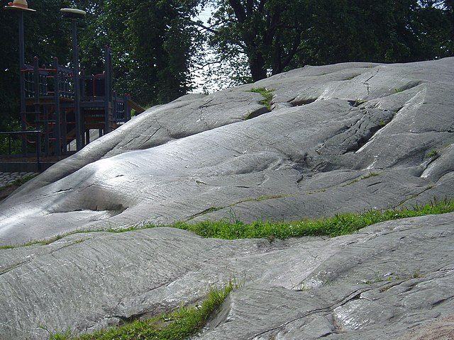
By adopting a systems approach and focusing on processes, it is possible to explore the activity of glacial streams at various spatial and temporal scales. Basal sliding and associated erosional processes can result in the formation of small-scale striations (see below), intermediate-scale Roche moutonées (see below), and large-scale U-shaped valleys (see Monega Hill). Glaciated landscapes can also be viewed as forming over entire glacial cycles lasting thousands of years. However, glacier outburst floods, or jökulhlaups, triggered by volcanic eruptions or the catastrophic release of water from ice or moraine-dammed lakes can cause dramatic landscape changes in a matter of hours or days.
While not explicitly stated, it is worthwhile exploring the relationships between cold environments, glaciated landscapes, and other forms of geomorphic processes. This allows for a more comprehensive investigation of the interlinkages between different aspects of the physical environment in terms of energy and materials. For example, the significant connection between glaciers, global and local sea level, and coastal forms can be studied. The impact of glacier retreat, for instance, is not limited to the formation of recessional moraines but can also be seen in the development of raised beaches resulting from crustal uplifts associated with the removal of thick ice cover and the corresponding fall in sea level.
Permafrost, designed ground, solifluction stores, and pingos
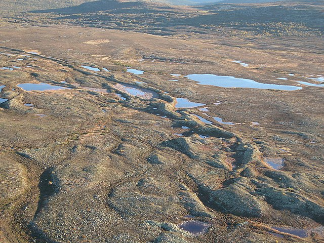
Permafrost, covering around 20-25% of the Earth’s surface, is defined as ground that remains consistently frozen. The outermost layer of soil in permafrost regions, known as the “active layer,” undergoes numerous daily freeze-thaw cycles and other events. The fluctuation in water volume causes coarser particles to migrate to the surface.
As ice moves and shifts, it sorts and arranges rocks and stones based on their size to form patterned or engineered ground. Larger rocks are arranged in circular formations called stone rings, which can merge and form polygonal nets. On steep slopes, these patterns are stretched into stone stripes by the gradual downhill movement of the saturated active layer. Polygonal cracks, initiated by contraction during extreme cold, form patterned ground in other areas. As water flows into these cracks and freezes during the spring thaw, the ice-filled cracks expand, forming ice wedges several meters deep and several centimeters wide at the top. The edges of these ice wedges distort and compress the soil. Relict engineered ground, formed during the last ice age, can persist long after the permafrost has thawed due to this distortion and sediment trapped in the cracks. Today, relict engineered ground is found over 1,000 kilometers south of the current permafrost limit.
When the active layer of permafrost moves due to gravity, it is called gelifluction, resulting in the folding and slumping of the soft flowing layer on slopes or at the base of slopes.
- Designed Ground: Designed ground is a term used to describe the patterns of sediment and soil that are left behind by glaciers. As glaciers move over the landscape, they pick up and transport sediment, leaving behind a distinctive pattern of ridges and troughs. These ridges and troughs are known as moraines and are formed from the deposition of sediment at the edges of the glacier. Designed ground can also refer to the patterns of erosion and deposition caused by the movement of water under and around the glacier.
- Solifluction Stores: Solifluction is the slow, downhill movement of soil and sediment that occurs in areas with permafrost. In glaciated landscapes, solifluction stores refer to the areas where this process has occurred. As glaciers retreat and permafrost thaws, the soil and sediment that was previously frozen can become unstable and begin to move downhill. This movement can create distinctive features such as terraces, lobes, and ridges.
- Pingos: Pingos are dome-shaped hills that are formed in permafrost regions. In glaciated landscapes, pingos can form when groundwater becomes trapped under the permafrost and freezes. As the water freezes, it expands and creates pressure, causing the surrounding sediment to be pushed upward. Over time, this can result in the formation of a hill. Pingos can be several meters to several hundred meters in height and are often surrounded by a moat-like depression.
Read more about Managing Glacial Landscapes
Frequently Asked Questions
How do glaciers shape the landscape?
Glaciers shape the landscape through processes like erosion, transportation, and deposition of rocks and sediments, forming features like U-shaped valleys and moraines.
What is a cirque, and how does it form?
A cirque is a bowl-shaped depression on a mountain formed by glacial erosion. Snow and ice accumulate, and the glacier’s movement erodes the surrounding rock.
How do glaciers contribute to the formation of fjords?
Glaciers erode U-shaped valleys that are later flooded by rising sea levels, creating fjords—narrow, deep coastal inlets.
What are moraines, and how do they indicate glacier movement?
Moraines are ridges of rocks and sediments deposited by glaciers. Terminal moraines mark the farthest extent of glacier movement, while lateral moraines form along the sides.
How has human activity affected glaciated landscapes?
Human activities like mining and tourism can lead to increased erosion and sedimentation in glaciated areas, impacting the delicate balance of these landscapes.
References
- Glaciated Landscape. (n.d.). Retrieved from Britainnica: https://www.britannica.com/science/glacial-landform/Periglacial-landforms
- Glaciated landscapes. (n.d.). Retrieved from Glaciated landscapes: https://www.rgs.org/CMSPages/GetFile.aspx?nodeguid=800779bf-f715-42f5-bf94-4d46b493e14b&lang=en-GB